Category:Ooievaarshorst, Leusden-Zuid
Jump to navigation
Jump to search
| Object location | | View all coordinates using: OpenStreetMap |
|---|
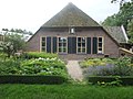
farmhouse in Leusden, Netherlands  | |||||
| Upload media | |||||
| Instance of | |||||
|---|---|---|---|---|---|
| Location | Leusden, Utrecht, Netherlands | ||||
| Street address |
| ||||
| Heritage designation |
| ||||
 | |||||
|
This is a category about rijksmonument number 25799
|
| Address |
|
Media in category "Ooievaarshorst, Leusden-Zuid"
The following 13 files are in this category, out of 13 total.
-
 Achtergevel - Leusden-Zuid - 20453579 - RCE.jpg 1,200 × 900; 162 KB
-
 Boerderij "Ooievaarshorst", overzicht - Leusden-Zuid - 20139222 - RCE.jpg 1,200 × 944; 268 KB
-
 Erf - Leusden-Zuid - 20453577 - RCE.jpg 1,200 × 900; 175 KB
-
 Erf - Leusden-Zuid - 20453578 - RCE.jpg 1,200 × 900; 173 KB
-
 Kopgevel uitbouw - Leusden-Zuid - 20453576 - RCE.jpg 1,200 × 900; 190 KB
-
 Ooievaarshorst leusden.jpg 3,656 × 2,053; 6.1 MB
-
 RM25799 Ooievaarshorsterweg 7.JPG 4,320 × 3,240; 2.06 MB
-
 Voor- en zijgevel - Leusden-Zuid - 20453581 - RCE.jpg 1,200 × 900; 172 KB
-
 Voorgevel - Leusden-Zuid - 20453575 - RCE.jpg 1,200 × 900; 162 KB
-
 Voorgevel - Leusden-Zuid - 20453580 - RCE.jpg 1,200 × 900; 193 KB
-
 Voorgevel - Leusden-Zuid - 20453583 - RCE.jpg 1,200 × 900; 178 KB
-
 Zij- en achtergevel - Leusden-Zuid - 20453584 - RCE.jpg 1,200 × 900; 152 KB
-
 Zij- en voorgevel - Leusden-Zuid - 20453582 - RCE.jpg 1,200 × 900; 190 KB


