Category:Oliestraat 18, Grave
Jump to navigation
Jump to search
| Object location | | View all coordinates using: OpenStreetMap |
|---|
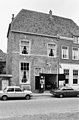
house in Grave, Netherlands  | |||||
| Upload media | |||||
| Instance of | |||||
|---|---|---|---|---|---|
| Location | Grave, Land van Cuijk, North Brabant, Netherlands | ||||
| Street address |
| ||||
| Located on street | |||||
| Heritage designation |
| ||||
 | |||||
|
This is a category about rijksmonument number 17291
|
| Address |
|
Media in category "Oliestraat 18, Grave"
The following 6 files are in this category, out of 6 total.
-
 Gevels - Grave - 20084155 - RCE.jpg 1,200 × 957; 287 KB
-
 Grave Rijksmonument 17291 Oliestraat 18.JPG 2,736 × 3,648; 3.58 MB
-
 Overzicht - Grave - 20084161 - RCE.jpg 1,200 × 952; 260 KB
-
 Overzicht Oliestraat - Grave - 20083604 - RCE.jpg 1,200 × 960; 187 KB
-
 Voorgevel - Grave - 20084151 - RCE.jpg 788 × 1,200; 215 KB
-
 Voorgevel - Grave - 20084152 - RCE.jpg 788 × 1,200; 230 KB


