Category:Old maps of the province of Bergamo
Jump to navigation
Jump to search
Subcategories
This category has only the following subcategory.
B
Pages in category "Old maps of the province of Bergamo"
This category contains only the following page.
Media in category "Old maps of the province of Bergamo"
The following 18 files are in this category, out of 18 total.
-
 "Territorio di Bergamo" (22066804938).jpg 3,912 × 2,994; 2.52 MB
-
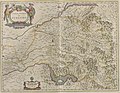
 Territorio di Bergamo - Atlas Maior, vol 9, map 10 - Joan Blaeu, 1667.jpg 771 × 1,028; 210 KB
-

-
-

-
 Dominii Veneti cum vicinis Parmae, Mutinae, Mantuae et Mirandolae Statibus Nova Descriptio.jpg 7,649 × 6,531; 19.69 MB
-

-
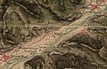
 Clusone (Second military survey of the Habsburg Empire, 1818-1829).jpg 700 × 455; 110 KB
-
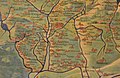
 Gorno-map.jpg 1,500 × 1,386; 562 KB
-
 Il Bergamasco diviso ne' suoi distretti - Venezia 1782 - by Antonio Zatta.jpg 2,904 × 3,475; 5.55 MB
-
 Nembro (Second military survey of the Habsburg Empire, 1818-1829).jpg 700 × 455; 101 KB
-

-

-
 Territorio di Bergamo (Musei Vaticani).jpg 700 × 455; 74 KB
-
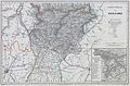
 Territorio di Bergamo - 1822 map of the Austrian Empire.jpg 631 × 853; 189 KB
-
 Treviglio (Second military survey of the Habsburg Empire, 1818-1829).jpg 800 × 511; 124 KB
-
 Vallardi - Bergamo.jpg 6,174 × 4,061; 11.41 MB
-
 Zogno (Second military survey of the Habsburg Empire, 1818-1829).jpg 700 × 455; 119 KB
.jpg)


.9.(20)_(cropped).jpg)
.9.(20).jpg)

_01.jpg)
.jpg)


.jpg)
.jpg)
.jpg)
.jpg)

.jpg)

.jpg)