Category:Old maps of the history of Berlin
Jump to navigation
Jump to search
Federal states of Germany:
Use the appropriate category for maps showing all or a large part of Berlin. See subcategories for smaller areas:
| If the map shows | Category to use |
|---|---|
| Berlin on a recently created map | Category:Maps of Berlin or its subcategories |
| Berlin on a map created more than 70 years ago | Category:Old maps of Berlin or its subcategories |
| the history of Berlin on a recently created map | Category:Maps of the history of Berlin or its subcategories |
| the history of Berlin on a map created more than 70 years ago | Category:Old maps of the history of Berlin or its subcategories |
Subcategories
This category has only the following subcategory.
Media in category "Old maps of the history of Berlin"
The following 16 files are in this category, out of 16 total.
-
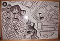 Alexanderplatz, Königstor um 1730.jpg 2,149 × 1,493; 525 KB
-
 Alt-Berlin-Koelln.jpg 1,369 × 1,920; 627 KB
-
 Alt-Biesdorf auf einer Karte von 1869.jpg 476 × 266; 72 KB
-
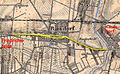 Alt-Biesdorf auf Karte 1869, nachbearbeitet.jpg 474 × 294; 69 KB
-
 BraeseckesReiseDurchBerlin 2017 11 25 Z.jpg 4,056 × 5,466; 9.42 MB
-
 Corridoi-aerei-Berlino.jpg 349 × 514; 109 KB
-
 Falk Oberdorf Wberlin transport 78.jpg 1,164 × 1,352; 568 KB
-
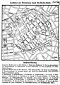
 Historischer Atlas von Berlin 1835 - Lehmgasse.jpg 2,129 × 1,625; 1.2 MB
-
 Kloeden Plan Berlin um 1230.JPG 606 × 553; 110 KB
-
 Klödenplan-Berlin-Kölln-Anfang-13tes-Jahrhundert.jpg 908 × 907; 334 KB
-
 Map de berlin 1710.jpg 2,244 × 1,710; 1.47 MB
-
 Plan von Berlin mit Bezeichnung der Barricaden am 18 u. 19ten Maerz 1848.jpg 3,923 × 2,973; 2.62 MB
-

-

-
 Spruner-Menke Handatlas 1880 Karte 45 Nebenkarte 1.jpg 1,457 × 1,105; 206 KB
-
 Wilhelmsruh Gebietsaustausch 1938.jpg 648 × 498; 73 KB


