Category:Old maps of the Dutch East India Company - Malaysia
Jump to navigation
Jump to search
Media in category "Old maps of the Dutch East India Company - Malaysia"
The following 17 files are in this category, out of 17 total.
-
 AMH-2559-NA Chart of part of the Malacca Straits.jpg 2,400 × 1,257; 418 KB
-
 AMH-4570-NA Map of the fort at Malakka.jpg 2,400 × 1,697; 756 KB
-
 AMH-4571-NA Map of the fort at Malakka.jpg 1,950 × 2,400; 691 KB
-
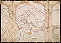
 AMH-4572-NA Map of the city and fort at Malakka.jpg 2,400 × 1,272; 413 KB
-
 AMH-4573-NA Map and elevation of the fort at Malakka.jpg 1,911 × 2,400; 734 KB
-
 AMH-4624-NA Views and maps of the Boegit China base near Malacca.jpg 2,400 × 2,141; 707 KB
-
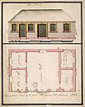 AMH-4625-NA Elevation and floor map of the Tranquera gate at Malacca.jpg 1,889 × 2,400; 765 KB
-
 AMH-4626-NA Map and elevation of the fort at Malacca.jpg 2,400 × 1,900; 703 KB
-
 AMH-5525-NA Map of Sumatra and the Malacca Straits.jpg 1,826 × 2,400; 900 KB
-
 AMH-5526-NA Map of Sumatra and the Malacca Straits.jpg 1,459 × 2,400; 714 KB
-
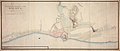
 AMH-6413-NA Map showing the roadstead of Malacca.jpg 2,400 × 2,352; 454 KB
-
 AMH-6618-NA Map of Malacca and environs.jpg 2,400 × 1,019; 279 KB
-
 AMH-6665-KB Two maps of Thailand, Malaysia and Sumatra.jpg 2,400 × 1,846; 1.05 MB
-
 AMH-6668-KB Map of Java, Sumatra, Borneo and Malaysia.jpg 2,400 × 1,914; 1.01 MB
-
 AMH-7109-KB Map of Malakka.jpg 2,400 × 2,078; 1.57 MB
-
 AMH-7928-KB Map of Sumatra, Java, Borneo and Malaysia.jpg 2,400 × 2,048; 1.05 MB
-
 AMH-7981-KB Map of Malacca.jpg 1,725 × 2,400; 620 KB


