Category:Old maps of islands of the Aegean Sea by Piri Reis
Jump to navigation
Jump to search
Media in category "Old maps of islands of the Aegean Sea by Piri Reis"
The following 32 files are in this category, out of 32 total.
-
 Piri Reis - Map of Chalkis Island Off Rhodes Island - Walters W658104A - Full Page.jpg 1,213 × 1,800; 2.61 MB
-
 Piri Reis - Map of Mykonos Island in the Aegean Sea - Walters W658116A - Full Page.jpg 1,225 × 1,799; 2.8 MB
-

-
 Piri Reis - Map of Rhodes Island - Walters W658103A - Full Page.jpg 1,231 × 1,799; 2.75 MB
-
-

-

-

-

-
-

-

-
-

-

-
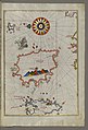
 Piri Reis - Map of the Island of Kalimnos - Walters W65888A - Full Page.jpg 1,213 × 1,800; 2.54 MB
-
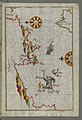
 Piri Reis - Map of the Island of Lemnos - Walters W65847A - Full Page.jpg 1,187 × 1,800; 2.64 MB
-
-
-
 Piri Reis - Map of the Island of Paros in the Aegean Sea - Walters W658112B - Full Page.jpg 1,222 × 1,799; 2.77 MB
-
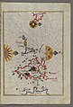
 Piri Reis - Map of the Island of Patmos - Walters W65884B - Full Page.jpg 1,223 × 1,799; 2.74 MB
-
 Piri Reis - Map of the Island of Syros in the Aegean Sea - Walters W658113B - Full Page.jpg 1,227 × 1,799; 2.59 MB
-

-
-

-

-
 Piri Reis - Map of Tinos Island in the Aegean Sea - Walters W658117A - Full Page.jpg 1,227 × 1,800; 2.87 MB
-

-

-

-
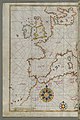 Piri Reis - Map of Western Europe and North Africa - Walters W65864A - Full Page.jpg 1,199 × 1,800; 2.88 MB
-


_with_the_City_of_Athens_-_Walters_W658121A_-_Full_Page.jpg)


