Category:Old maps of departments of Uruguay
Jump to navigation
Jump to search
Subcategories
This category has only the following subcategory.
Media in category "Old maps of departments of Uruguay"
The following 21 files are in this category, out of 21 total.
-
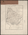
 BERRA(1882) p357 MAPA DE LA REPUBLICA ORIENTAL DEL URUGUAY.jpg 1,765 × 2,355; 2.65 MB
-
 BERRA(1882) p371 PLANO DEL DEPARTEMENTO DE CANELONES.jpg 2,731 × 1,779; 2.51 MB
-
 BERRA(1882) p373 PLANO DEL DEPARTEMENTO DE LA FLORIDA.jpg 1,777 × 2,752; 2.81 MB
-
 BERRA(1882) p375 PLANO DEL DEPARTEMENTO DEL DURANZO.jpg 2,757 × 1,785; 2.95 MB
-
 BERRA(1882) p377 PLANO DEL DEPARTEMENTO DEL MALDONADO.jpg 1,785 × 2,736; 2.75 MB
-
 BERRA(1882) p379 PLANO DEL DEPARTEMENTO DE MINAS.jpg 1,785 × 2,736; 2.55 MB
-
 BERRA(1882) p381 PLANO DEL DEPARTEMENTO DEL CERRO LARGO.jpg 2,773 × 1,795; 2.64 MB
-
 BERRA(1882) p383 PLANO DEL DEPARTEMENTO DE ROCHA.jpg 1,793 × 2,768; 2.75 MB
-
 BERRA(1882) p385 PLANO DEL DEPARTEMENTO DE SAN JOSE.jpg 1,857 × 2,768; 3.09 MB
-
 BERRA(1882) p387 PLANO DEL DEPARTEMENTO DE LA COLONIA.jpg 2,755 × 1,809; 2.76 MB
-
 BERRA(1882) p389 PLANO DEL DEPARTEMENTO DE SORIANO.jpg 2,783 × 1,773; 2.88 MB
-
 BERRA(1882) p391 PLANO DEL DEPARTEMENTO DEL RIO NEGRO.jpg 2,743 × 1,779; 2.56 MB
-
 BERRA(1882) p393 PLANO DEL DEPARTEMENTO DE PAYSANDU.jpg 2,771 × 1,787; 2.53 MB
-
 BERRA(1882) p395 PLANO DEL DEPARTEMENTO DEL SALTO.jpg 2,753 × 1,763; 2.46 MB
-
 BERRA(1882) p397 PLANO DEL DEPARTEMENTO DE TACUAREMBO.jpg 2,755 × 1,761; 2.65 MB
-
 MAPA DE LA REPUBLICA ORIENTAL DEL URUGUAY.jpg 1,565 × 2,097; 1.63 MB
-

-
 ABN recuerdo montevideo galli mapa uruguay.jpg 1,760 × 2,255; 1.01 MB
-
 Map of the Eastern Republic of Uruguay, 1893 WDL11330.png 1,024 × 1,169; 2.31 MB
-
 Servicio Correos De La República Oriental Del Uruguay.jpg 6,284 × 8,365; 12.88 MB
-
 Uruguay WDL11331.png 1,024 × 1,289; 2.18 MB
_p357_MAPA_DE_LA_REPUBLICA_ORIENTAL_DEL_URUGUAY.jpg)
_p371_PLANO_DEL_DEPARTEMENTO_DE_CANELONES.jpg)
_p373_PLANO_DEL_DEPARTEMENTO_DE_LA_FLORIDA.jpg)
_p375_PLANO_DEL_DEPARTEMENTO_DEL_DURANZO.jpg)
_p377_PLANO_DEL_DEPARTEMENTO_DEL_MALDONADO.jpg)
_p379_PLANO_DEL_DEPARTEMENTO_DE_MINAS.jpg)
_p381_PLANO_DEL_DEPARTEMENTO_DEL_CERRO_LARGO.jpg)
_p383_PLANO_DEL_DEPARTEMENTO_DE_ROCHA.jpg)
_p385_PLANO_DEL_DEPARTEMENTO_DE_SAN_JOSE.jpg)
_p387_PLANO_DEL_DEPARTEMENTO_DE_LA_COLONIA.jpg)
_p389_PLANO_DEL_DEPARTEMENTO_DE_SORIANO.jpg)
_p391_PLANO_DEL_DEPARTEMENTO_DEL_RIO_NEGRO.jpg)
_p393_PLANO_DEL_DEPARTEMENTO_DE_PAYSANDU.jpg)
_p395_PLANO_DEL_DEPARTEMENTO_DEL_SALTO.jpg)
_p397_PLANO_DEL_DEPARTEMENTO_DE_TACUAREMBO.jpg)

.jpg)


