Category:Old maps of Upper Lusatia
Jump to navigation
Jump to search
| NO WIKIDATA ID FOUND! Search for Old maps of Upper Lusatia on Wikidata | |
| Upload media |
Subcategories
This category has the following 2 subcategories, out of 2 total.
O
- Oberlausitzkarte, Schenk, 1759 (204 F)
Media in category "Old maps of Upper Lusatia"
The following 30 files are in this category, out of 30 total.
-
 1169-3110 MG 1751.jpg 2,000 × 1,456; 636 KB
-
 Tabula Compendia Saxoniae komplett.jpg 3,768 × 2,245; 12.29 MB
-
 Tabula Compendia Saxoniae.jpg 7,257 × 6,007; 58.97 MB
-
 Das Lausitzer Gebirge und die umliegenden Gegenden.jpg 7,373 × 6,029; 17.54 MB
-
 Ernst Muckas Karte der Lausitz (1886).jpg 2,702 × 3,976; 6.99 MB
-
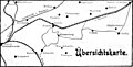 Klosterberg in der Oberlausitz - Übersichtskarte von Georg Pauli 1911.jpg 2,303 × 1,167; 976 KB
-
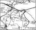 Landkarte zum Klosterberg in der Oberlausitz von Georg Pauli 1911.jpg 2,792 × 2,327; 1.64 MB
-

-
 Bautzen, Görlitz.jpg 7,462 × 6,610; 20.95 MB
-
 Blaeu 1645 - Lusatia Superior.jpg 3,720 × 3,120; 1.3 MB
-
 Blaeu 1645 - Saxonia Superior cum Lusatia et Misnia.jpg 3,720 × 3,120; 1.26 MB
-
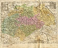
 Die Ober Lausitz Koenigl. Saechsischen Antheils 1832.jpg 6,609 × 5,260; 8.26 MB
-
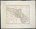
 Die Ober Lausitz Koenigl. Saechsischen Antheils.jpg 5,774 × 4,666; 7.06 MB
-

-
 Karte Lausitz 1715.png 7,832 × 5,489; 97.48 MB
-
 Karte Oberlausitz 1633.png 7,941 × 5,665; 76.35 MB
-
 Lausitz map 18thC.jpg 1,624 × 1,383; 3.01 MB
-
 Lusatia Superior - Auth. Bartholomæo Sculteto Gorlitio, ca.1630.jpg 7,810 × 6,632; 6.43 MB
-
 Lusatia Superior - Auth. Bartholomæo Sculteto Gorlitio, ca.1700.jpg 7,483 × 5,614; 6.2 MB
-
 Lusatia superior mapa.jpg 3,178 × 2,508; 747 KB
-
 Luther region 1519.png 1,119 × 712; 2.3 MB
-
 Lvsatia Superior (Merian).jpg 1,599 × 1,276; 627 KB
-
 Meiche Karte1 2024 05 30 grau.jpg 4,516 × 4,000; 2.23 MB
-
 Meiche Karte2 2024 05 30 grau.jpg 4,560 × 4,000; 2.58 MB
-
 Ober-Lausitz.jpg 4,218 × 3,415; 3.38 MB
-
 Reilly 103.jpg 1,260 × 952; 576 KB
-
 Smoler korta01.jpg 1,539 × 2,202; 2.75 MB
-
 Tabula Geographica Marchionat. Misniae et Lusatiae.jpg 5,019 × 4,426; 9.87 MB
-
 Upper Lusatia map 1600.jpg 1,800 × 1,265; 572 KB
-
 Země Koruny české.jpg 2,847 × 2,260; 1.11 MB


.jpg)


.jpg)


.jpg)


