Category:Old maps of Sarajevo
Jump to navigation
Jump to search
Pages in category "Old maps of Sarajevo"
This category contains only the following page.
Media in category "Old maps of Sarajevo"
The following 22 files are in this category, out of 22 total.
-
 Sarajevo. NYPL1226988 (cropped).tiff 1,413 × 678; 2.91 MB
-
 Sarajevo. NYPL1226988.tiff 5,147 × 4,320; 52.72 MB
-
 Bosnien-Herzegowina BV043430366.jpg 9,985 × 9,067; 8.75 MB
-
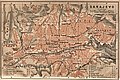
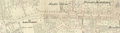
 Sarajevo 1887.jpg 1,407 × 712; 232 KB
-

-
 Narrow-Gauge-Railway Ostbahn Map Sarajevo 1905.jpg 1,600 × 1,060; 2.09 MB
-
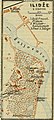
 Sarajevo 1905.jpg 1,170 × 782; 324 KB
-

-
-
 Walnys Plan von Sarajevo und Umgebung.jpg 12,234 × 8,914; 17.89 MB
-
 Bosnien-Herzegowina BV042770243.jpg 3,774 × 2,589; 2.18 MB
-
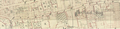
 Sarajevo 1929.jpg 2,895 × 1,232; 2.28 MB
-
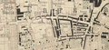
 Sarajevo 1930s.jpg 1,007 × 765; 297 KB
-
 Ferhadija 1882.png 1,766 × 433; 1.57 MB
-
 Hastahana 1882.png 1,137 × 475; 1.1 MB
-
 P.453-fig.166-Palæolithic Man and Terramara Settlements in Europe.jpg 1,024 × 553; 96 KB
-
 Saraci 1882.png 1,140 × 521; 1.38 MB
-
 Sarajevo Map Prirucni-Plan-Grada-Sarajeva 1932.jpg 22,136 × 15,550; 58.86 MB
-
 Sarajevo Map Prirucni-Plan-Grada-Sarajeva 1949.jpg 3,301 × 2,271; 3.76 MB
-
 Stari grad Vratnik mapa.png 1,503 × 1,359; 2.31 MB
-
 Titova 1882.png 1,545 × 422; 1.24 MB
-
 Trg oslobodjenja 1882.png 905 × 526; 996 KB


%27_(11303085424).jpg)


_(14592740728).jpg)
_(14756384126).jpg)


