Category:Old maps of Rendsburg
Jump to navigation
Jump to search
Subcategories
This category has only the following subcategory.
Media in category "Old maps of Rendsburg"
The following 10 files are in this category, out of 10 total.
-
 Plan af fæstningen Rendsborg omkring 1720.jpg 5,117 × 6,319; 8.84 MB
-
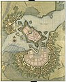
 Camerer Rendsburg (1756).jpg 592 × 427; 215 KB
-

-

-
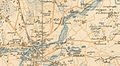 Audorfer-see-1880-vor-bau-nok.jpg 467 × 258; 84 KB
-

-

-
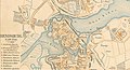 Rendsburg auf Karte von 1880.jpg 1,909 × 1,034; 461 KB
-
 Tysklandsbrigaden, øvelse Skandia III - Fo30141603010077.jpg 7,282 × 7,294; 16.59 MB
-
 Tysklandsbrigaden, øvelse Skandia III - Fo30141603010078.jpg 7,282 × 7,294; 16.87 MB

.jpg)
.jpg)
.jpg)


