Category:Old maps of Panama from the Norman B. Leventhal Map Center
Jump to navigation
Jump to search
Media in category "Old maps of Panama from the Norman B. Leventhal Map Center"
The following 4 files are in this category, out of 4 total.
-
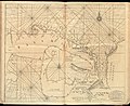 Darien Nautical Chart 1737.jpg 6,704 × 5,460; 8.08 MB
-
 Panama Nautical Chart 1775.jpg 7,855 × 5,959; 11.81 MB
-

-
 Plan of the town, road, and harbour of Chagre ; Plan of Porto Belo (18160894958).jpg 1,465 × 2,000; 2.2 MB


.jpg)
.jpg)