Category:Old maps of Palermo
Jump to navigation
Jump to search
Subcategories
This category has the following 4 subcategories, out of 4 total.
1
Media in category "Old maps of Palermo"
The following 35 files are in this category, out of 35 total.
-
 "Plan de la Ville, Port et Rades de Palerme" (22231756932).jpg 3,267 × 2,429; 1.69 MB
-
 1736 Palermo detail West Part of Barbary map by Herman Moll BPL 14639.png 1,245 × 473; 1.21 MB
-
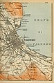
 The Gulf of Palermo.png 5,412 × 4,284; 32.45 MB
-
 1834 map of Palermo by Antonio Musumeci.jpg 20,214 × 13,670; 42.86 MB
-

-
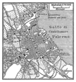
 Karte Palermo MKL1888.png 372 × 403; 55 KB
-
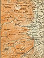
 Stielers Handatlas 1891 26.jpg 4,200 × 5,150; 5.05 MB
-
 Palermo carta12.jpg 337 × 520; 35 KB
-
 Palermo carta232.jpg 1,145 × 987; 422 KB
-

-
 Admiralty Chart No 169 Sicily Palermo Bay, Published 1877.jpg 10,115 × 8,072; 12.93 MB
-
 Book of Curiosities - Sicily map.jpg 3,200 × 2,182; 4.94 MB
-

-
 Gezicht op Palermo te Sicilië in vogelvlucht, RP-P-2018-3413.jpg 3,204 × 2,506; 1.39 MB
-
 Golfe de Palerme - Roux Joseph - 1804.jpg 1,500 × 1,054; 722 KB
-

-
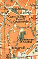
 Italy; handbook for travellers (1900) (14784541622).jpg 1,960 × 1,616; 444 KB
-
 Karte Via Roma (Palermo).png 1,890 × 1,898; 1.51 MB
-
 La citta di Palermo LOC 2012590072.jpg 8,561 × 6,287; 10.78 MB
-
 La citta di Palermo LOC 2012590072.tif 8,561 × 6,287; 153.99 MB
-

-
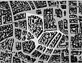
 Meyers b12 s0626 b1.png 391 × 423; 106 KB
-
 Palermo - btv1b8491183g.jpg 8,940 × 6,730; 10.27 MB
-
 Palermo Giudecca.jpg 844 × 648; 118 KB
-
 Palermo map at time of Garibaldi's entrance May 27, 1860.jpg 984 × 1,307; 273 KB
-

-

-
 Pianta di Palermo e adiacenze - 27-30 maggio 1860.jpg 2,093 × 1,318; 599 KB
-

-
 Plattegrond van Palermo Palermo (titel op object), BI-B-FM-090-73.jpg 3,602 × 2,620; 1.22 MB
-
-
-

-
 Wolf-Dietrich-Klebeband Städtebilder G 141 III.jpg 2,000 × 1,499; 1.45 MB
-
 Silizien. 2, Palermo 1905 (139963193).jpg 2,673 × 3,944; 9.04 MB
.jpg)


%27_(11254258523).jpg)


%27_(11264159186).jpg)


_(14792833833).jpg)
_(14784541622).jpg)
.png)

_at_Palazzo_Lanza_Tomasi_at_Palermo,_now_at_exhibition_%22Giuseppe_Tomasi_di_Lampedusa_(1896-1957)-_un_lettore_europeo%22,_up_to_July_10,_2018_at_Royal_Palace_in_Naples_-_28064606437.jpg)


n(i)_1580_-_btv1b8440462n.jpg)


_Panormus_vernacule_Palermo_(titel_op_object),_RP-P-2018-1218.jpg)
,_BI-B-FM-090-73.jpg)
_(14740394906).jpg)
_(14576701050).jpg)
_(14763062672).jpg)

.jpg)