Category:Old maps of Northampton
Jump to navigation
Jump to search
Subcategories
This category has only the following subcategory.
G
Media in category "Old maps of Northampton"
The following 7 files are in this category, out of 7 total.
-
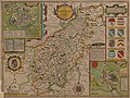 Speed Northampton.jpg 6,240 × 4,680; 24.29 MB
-
 Ordnance Survey Half-inch Sheet 23 Birmingham Leamington & Northampton, Published 1925.jpg 11,875 × 8,931; 11.66 MB
-
 A Map of the borough of Northampton, corrected to january 1878... - btv1b84390295.jpg 8,782 × 8,179; 8.52 MB
-
 Cole-roper northampton 1810.jpg 563 × 740; 154 KB
-
 Extract fro OS Maps SP75 and SP76.jpg 1,579 × 3,553; 4.3 MB
-
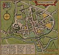 Map of Northampton, 1610, John Speed.jpg 1,774 × 1,656; 1.95 MB
-
 Ordnance Survey One-Inch Sheet 83 Northampton, Published 1919.jpg 11,817 × 8,810; 38.55 MB


