Category:Old maps of Nariño Department
Jump to navigation
Jump to search
Media in category "Old maps of Nariño Department"
The following 9 files are in this category, out of 9 total.
-
 Carta Corográfica del Estado del Cauca (1871).jpg 2,216 × 4,104; 3.74 MB
-
 Carta Corográfica Del Estado Del Cauca.jpg 8,147 × 14,847; 11.21 MB
-
-
 Carta del Departamento del Cauca.jpg 4,361 × 6,129; 7.25 MB
-
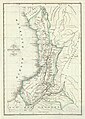
 Mapa Corográfico de la Provincia de Barbacoas (1853).jpg 3,648 × 4,336; 5.55 MB
-
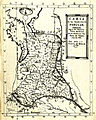
 Mapa Corográfico de la Provincia de Túquerres (1853).jpg 3,205 × 4,521; 6.61 MB
-
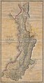 Mapa del Estado del Cauca (1865).jpg 4,544 × 8,528; 13.36 MB
-
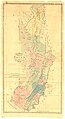 Mapa del Estado del Cauca (1871).jpg 4,734 × 8,686; 6.18 MB
-
 Vulkane bei Cumbal.jpg 5,409 × 3,621; 3.69 MB
.jpg)

_-_AHG.jpg)

.jpg)
.jpg)
.jpg)
.jpg)
