Category:Old maps of Nøtterøy
Jump to navigation
Jump to search
Media in category "Old maps of Nøtterøy"
The following 11 files are in this category, out of 11 total.
-
-
 Jarlsberg og Larviks amt nr 10- Fridrichsøer Fridrichshafn, 1772.jpg 7,780 × 5,952; 5.11 MB
-
 Jarlsberg og Larviks amt nr 3- Kart over Tønsbergs Havn, 1730.jpg 6,783 × 5,146; 4.51 MB
-
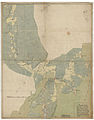
 Kart over kysten fra Fredriksvern til Nøtterøy, inkl Tønsberg.png 4,285 × 2,857; 35.03 MB
-
 Kart over Tønsberg, veier og kyst.png 3,522 × 3,537; 25.09 MB
-
 Sjøkart over havområdet mellom Nøtterøy og Tjøme fra 1707.png 4,000 × 3,124; 25.07 MB
-
 Sjøkart over havområdet mellom Tønsberg og Nøtterøy fra ukjent årstall.png 4,054 × 3,066; 23.9 MB
-
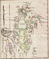 Sjøkart over Nøtterøy og Tjøme fra ukjent årstall.png 2,816 × 3,405; 20.66 MB
-
 Sjøkart over Tønsberg havn fra ukjent årstall 2.png 4,458 × 2,773; 23.61 MB
-
 Sjøkart over Tønsberg havn fra ukjent årstall.png 2,864 × 3,407; 20.66 MB
-
 Sjøkart over utseilingen fra Tønsberg fra ukjent årstall.png 3,092 × 3,562; 22.94 MB


