Category:Old maps of Methoni
Jump to navigation
Jump to search
Subcategories
This category has only the following subcategory.
1
Media in category "Old maps of Methoni"
The following 12 files are in this category, out of 12 total.
-

-
 Eylanden onder de Kust van Modon - Dapper Olfert - 1688.jpg 1,500 × 1,210; 992 KB
-
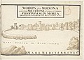
 Modon1770.jpg 1,200 × 748; 248 KB
-
 Admiralty Chart No 719 Harbours and Anchorages on the South-West Coast of Greece, Published 1964.jpg 11,016 × 8,246; 18.95 MB
-
 Atlante Neroni - Modone.jpg 2,289 × 1,495; 860 KB
-
-

-
 Modon - Peeters Jacob - 1686.jpg 1,500 × 795; 573 KB
-
 Modon - Peeters Jacob - 1690.jpg 1,500 × 801; 768 KB
-
 Modon - Sandrart Jacob Von - 1686.jpg 1,342 × 814; 1.04 MB
-
 Modon - Sandrart Jacob Von - 1687.jpg 1,500 × 862; 910 KB
-


.jpg)
_-_Camocio_Giovanni_Francesco_-_1574.jpg)


_-_(Fran%C3%A7ois_de_Belleforest)_-_btv1b53078098f_(1_of_2).jpg)