Category:Old maps of Marburg
Jump to navigation
Jump to search
Subcategories
This category has only the following subcategory.
M
Media in category "Old maps of Marburg"
The following 13 files are in this category, out of 13 total.
-
 After Action Report - Marburg - NARA - 100384915.jpg 10,807 × 7,768; 23.14 MB
-
 Deutsch-Ordens-Haus Marburg (Schönbornplan).jpg 2,937 × 2,278; 2.18 MB
-
 Deutsch-Ordens-Haus Marburg 1750 HStAM karten nr p ii 10054 r.jpg 3,874 × 2,636; 1.41 MB
-
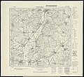
 Hessen Meßtischblatt 5118 Marburg 1942.jpg 1,600 × 1,460; 1.01 MB
-
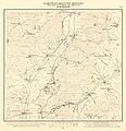
 Hessen Meßtischblatt 5218 Niederwalgern 1937.jpg 1,600 × 1,469; 1.02 MB
-
 Kurfürstentum Hessen Blatt 60 Marburg.jpg 6,141 × 6,377; 8.05 MB
-
 Kurfürstentum Hessen Blatt 70 Niederweimar.jpg 6,141 × 6,377; 6.75 MB
-
 Kurhessen Kr Marburg.png 249 × 402; 61 KB
-
 Marburg Elisabethmühle hstam karten nr p iii 361 r.jpg 1,003 × 1,519; 215 KB
-
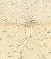
 Topografische Karte Lahntal 1857.jpg 5,600 × 5,419; 15.14 MB
-
 Topografische Karte Marburg 1857.JPG 4,174 × 2,275; 3.13 MB
-
 Topografische Karte Marburg Stadt 1857.JPG 2,842 × 2,335; 5.75 MB
-
 Topografische Karte Marburg und Umgebung 1857.jpg 5,516 × 6,459; 22.71 MB

.jpg)


