Category:Old maps of Kristianstad
Jump to navigation
Jump to search
Media in category "Old maps of Kristianstad"
The following 8 files are in this category, out of 8 total.
-
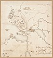
 110 of 'Kriget mot Danmark 1675-1679 ... Med porträtt, kartor, etc' (11177569024).jpg 1,373 × 2,272; 635 KB
-
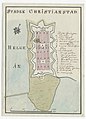 18th century map of Kristianstad, Sweden.jpg 2,916 × 4,050; 708 KB
-
 Situationsplan af Kristianstad, Nordisk familjebok.png 1,474 × 1,806; 105 KB
-

-

-
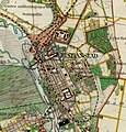 Häradsekonomiska kartan 1926-1934 Kristianstad.jpg 656 × 683; 161 KB
-
 Kungsboken-karta-kristianstad.jpg 3,013 × 3,283; 767 KB
-
 Map Kristianstad Sweden.jpg 1,872 × 2,808; 5.85 MB
.jpg)


.jpg)
.jpg)


