Category:Old maps of Kennebec County, Maine
Jump to navigation
Jump to search
Counties of Maine: Androscoggin · Aroostook · Cumberland · Franklin · Hancock · Kennebec · Knox · Lincoln · Oxford · Penobscot · Piscataquis · Sagadahoc · Somerset · Waldo · Washington · York
Subcategories
This category has the following 6 subcategories, out of 6 total.
Media in category "Old maps of Kennebec County, Maine"
The following 23 files are in this category, out of 23 total.
-
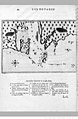 (Illustrations de Les Voyages de (...)Champlain Samuel btv1b2000019z.jpg 1,024 × 1,566; 420 KB
-

-

-
 A copy of ... the fourth and fifth ranges of townships in the Kennebec Million Acres LOC 91685214.tif 12,602 × 5,335; 192.35 MB
-
 A sketch of the north part of the Kennebec Million Acres. LOC 91685216.jpg 5,840 × 4,654; 4.04 MB
-
 A sketch of the north part of the Kennebec Million Acres. LOC 91685216.tif 5,840 × 4,654; 77.76 MB
-

-

-
 Map of the city of Augusta, capital of the state of Maine LOC 2008624046.jpg 9,560 × 10,826; 10.42 MB
-
 Map of the city of Augusta, capital of the state of Maine LOC 2008624046.tif 9,560 × 10,826; 296.11 MB
-
 Map of Kennebec Co., Maine LOC 2012592366.jpg 16,704 × 16,378; 40.24 MB
-
 Bird's eye view of Gardiner and Pittston, Kennebec Co., Maine, 1878 LOC 80693968.jpg 8,608 × 5,904; 11.44 MB
-
 Bird's eye view of Gardiner and Pittston, Kennebec Co., Maine, 1878 LOC 80693968.tif 8,608 × 5,904; 145.4 MB
-
 Bird's eye view of the city of Augusta, Maine, 1878 LOC 2007626387.jpg 9,033 × 6,031; 9.96 MB
-
 Bird's eye view of the city of Hallowell, Kennebec Co., Maine 1878. LOC 73694691.jpg 8,240 × 4,592; 6.78 MB
-
 Birds eye view of Waterville, Kennebec Co. Maine (2675086849).jpg 2,000 × 1,409; 2.36 MB
-

-

-
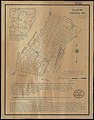 Map of Vienna, Me. (10176663555).jpg 629 × 800; 99 KB
-
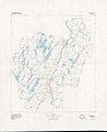
 Map of Pond Town Plantation, Maine (10089806583).jpg 620 × 799; 95 KB
-
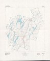
 Pondtownmap1908.tif 6,461 × 7,999; 295.75 MB
-
 Kennebec County, Maine LOC 81690041.jpg 7,375 × 8,996; 6.15 MB
-
 Kennebec County, Maine LOC 81690041.tif 7,375 × 8,996; 189.82 MB
Champlain_Samuel_btv1b2000019z.jpg)


.jpg)
.jpg)
.jpg)
.jpg)
.jpg)
