Category:Old maps of Kannur
Jump to navigation
Jump to search
Subcategories
This category has only the following subcategory.
M
Media in category "Old maps of Kannur"
The following 12 files are in this category, out of 12 total.
-
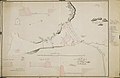
 AMH-2583-NA Maps of the forts at Cananor, Cranganor, Coylan and Calicoilan.jpg 2,400 × 1,737; 564 KB
-
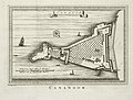
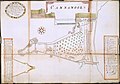 AMH-2584-NA Map of the fort at Cananoor.jpg 2,400 × 1,674; 571 KB
-
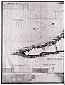
 AMH-2585-NA Plan to reduce the fort at Cananoor.jpg 1,859 × 2,400; 670 KB
-
 AMH-2586-NA Plan to reduce the fort at Cananoor.jpg 2,400 × 1,551; 475 KB
-
 AMH-2587-NA Plan to reduce the fort at Cananoor, with some changes.jpg 2,400 × 1,554; 355 KB
-
 AMH-4482-NA Planned reduction of the fort at Cananoor with several changes.jpg 2,400 × 1,564; 393 KB
-
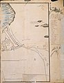
 AMH-5118-NA Map of the west coast of India.jpg 2,400 × 1,695; 491 KB
-
 AMH-5351-NA Photograph of a map with a plan to make the fort at Cananoor smaller.jpg 1,835 × 2,400; 578 KB
-
 AMH-8014-KB Floor plan of the fort Cananoor.jpg 2,400 × 1,820; 875 KB
-
 Fortaleza de cananor.jpg 6,038 × 4,166; 6 MB
-
 Kannur(Cananore) in the Malabar Providence.jpg 960 × 540; 108 KB
-


_in_the_Malabar_Providence.jpg)
.jpg)