Category:Old maps of Irkutsk
Jump to navigation
Jump to search
Media in category "Old maps of Irkutsk"
The following 15 files are in this category, out of 15 total.
-
 Drawing Book of Siberia 18 map.jpeg 2,860 × 2,005; 3 MB
-
 Чертеж земли Иркутского города.jpg 3,400 × 2,400; 1.41 MB
-
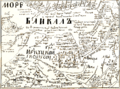 Baikal sea.png 787 × 583; 105 KB
-
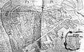
 Map of Irkutsk City in 1701.jpg 279 × 181; 89 KB
-
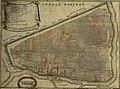 Plan goroda Irkutska (1730).jpg 2,103 × 1,553; 1.04 MB
-
 План города Иркутска (1768).jpg 862 × 530; 167 KB
-
 1800 Irkutsk detail of map Russian Empire by Mathew Carey BPL 12319.png 1,071 × 747; 1.53 MB
-
 SEMIVSKY(1817) p032.jpg 1,113 × 1,117; 807 KB
-
 159 of 'Письма о восточной Сибири' (11006591755).jpg 1,201 × 1,988; 536 KB
-
 MARTOS(1827) p159 Map of Irkutsk.jpg 1,004 × 1,625; 909 KB
-
 2 карта Иркутска 19 века.JPG 1,580 × 1,044; 401 KB
-
 Irkutsk 1903.jpg 9,322 × 7,411; 50.82 MB
-
 Irkutsk 1915.jpg 8,958 × 6,935; 46.16 MB
-
 Plan goroda Irkutska LOC 92680098.jpg 10,388 × 8,109; 12.62 MB
-
 Plan goroda Irkutska LOC 92680098.tif 10,388 × 8,109; 241 MB


.jpg)
.jpg)

_p032.jpg)
.jpg)
_p159_Map_of_Irkutsk.jpg)


