Category:Old maps of Huissen
Jump to navigation
Jump to search
Media in category "Old maps of Huissen"
The following 6 files are in this category, out of 6 total.
-
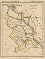 Gemeentekaart Huissen 1867.jpg 586 × 768; 181 KB
-
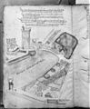
 Huissen Altes Lagerboick & Newer Register.jpg 2,187 × 3,492; 1.48 MB
-
 Kadastrale kaart Gemeente Huissen 1818.jpg 7,051 × 4,809; 4.59 MB
-
 Kadastrale kaart Huissen, 1818.jpg 6,418 × 4,463; 3.89 MB
-
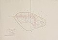
 Reproductie van tekening - Huissen - 20118229 - RCE.jpg 992 × 1,200; 329 KB
-
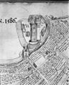 Reproductie van tekening - Huissen - 20118230 - RCE.jpg 971 × 1,200; 372 KB


