Category:Old maps of Emmerich am Rhein
Jump to navigation
Jump to search
Subcategories
This category has only the following subcategory.
Media in category "Old maps of Emmerich am Rhein"
The following 7 files are in this category, out of 7 total.
-
 Emmerik 1649 Blaeu.jpg 5,500 × 4,148; 2.45 MB
-

-
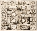
 Embrica. Emmerich - btv1b53211546n (1 of 2).jpg 4,973 × 1,419; 2.05 MB
-
 Karte des Deutschen Reiches - 327 - Cleve (1901).png 7,355 × 6,425; 90.47 MB
-
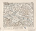 Karte des Deutschen Reiches - 327 - Cleve (1904).jpg 7,355 × 6,425; 17.27 MB
-
 Lambert-van-den-Bos-Lieuwe-van-Aitzema-Historien-onses-tyds MGG 0406.tif 4,146 × 3,485; 41.38 MB
-
 Nieuwe Kaart Van Het Hertogdom Kleef-cropped.jpg 2,064 × 1,425; 1.18 MB


.png)
.jpg)

.jpg)