Category:Old maps of Brazil from the Norman B. Leventhal Map Center
Jump to navigation
Jump to search
Media in category "Old maps of Brazil from the Norman B. Leventhal Map Center"
The following 8 files are in this category, out of 8 total.
-
 Brazil - from official and other sources (14773171969).jpg 1,929 × 2,000; 4.11 MB
-
 Brésil - carte politique et économique (14959850335).jpg 2,000 × 1,974; 4.72 MB
-
 Carta geral do estado de S. Paulo (14961561852).jpg 2,000 × 1,341; 2.64 MB
-
-
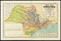
 Carte de voies de communication du Brésil (14775299148).jpg 2,000 × 1,738; 3.92 MB
-
 Carte economique du Brésil (14959851175).jpg 1,907 × 2,000; 3.99 MB
-
 Mapa do Brazil - (esboço) (outline) (14773238608).jpg 1,990 × 2,000; 4.18 MB
-
 Mappa geral do Brasil (14773171129).jpg 1,849 × 2,000; 4.04 MB
.jpg)
.jpg)
.jpg)
.jpg)
.jpg)
.jpg)
_(outline)_(14773238608).jpg)
.jpg)