Category:Old maps of Blaye (Gironde)
Jump to navigation
Jump to search
Media in category "Old maps of Blaye (Gironde)"
The following 5 files are in this category, out of 5 total.
-
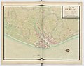 Plan de Blaye 1693.jpg 6,348 × 5,022; 3.67 MB
-

-
 Blaye 1661 Zeiller 15214.jpg 3,982 × 2,535; 6.13 MB
-
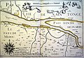 Capitainerie Brouage Tassin 16920.jpg 4,037 × 2,783; 9.72 MB
-
 Île et rade de Blaye - btv1b53143112f.jpg 7,852 × 6,592; 5.38 MB

_-_dessin%C3%A9s_par..._-_btv1b52503974g_(057_of_106).jpg)


