Category:Old maps of Bilbao
Jump to navigation
Jump to search
Subcategories
This category has only the following subcategory.
M
Media in category "Old maps of Bilbao"
The following 22 files are in this category, out of 22 total.
-

-
 Bakearen portua, Silvestre Perez, 1807.jpg 1,540 × 1,140; 502 KB
-
 Plan de Bilbao pendant les sièges de 1835 et 1836 - Lith. de Bernain - btv1b530352336.jpg 6,162 × 4,945; 3.53 MB
-
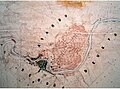
 Bilbo setioa 1836.jpg 1,200 × 722; 359 KB
-
 Bilbo setioa 1839 01.jpg 1,200 × 930; 209 KB
-
 Bilbo Coello 1857.jpg 435 × 455; 266 KB
-
 Plan de Ensanche para Bilbao por Amado de Lázaro, 1862.jpg 770 × 570; 116 KB
-

-
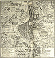
 Spain and Portugal- handbook for travellers (1901) (14773407681).jpg 1,374 × 1,856; 993 KB
-
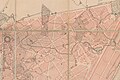
 Bilboko zabalgunea 1903an.jpg 7,662 × 3,682; 6.37 MB
-
 Zabalguneko zirkoa - Bilboko zabalgunea 1903an (cropped).jpg 393 × 308; 74 KB
-
 1915 Bilbao.jpg 1,600 × 1,237; 691 KB
-
 Admiralty Chart No 74 Abra de Bilbao, Published 1932.jpg 16,424 × 11,352; 62.11 MB
-
 Deustuko Erribera, 1956.png 1,200 × 850; 969 KB
-
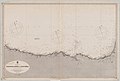 Admiralty Chart No 2728 Spain north coast Bidassoa River to Cape Peñas, Published 1887.jpg 12,204 × 8,287; 10.5 MB
-
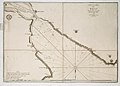
 Admiralty Chart No 2925 San Sebastian to Santander, Published 1934.jpg 17,631 × 11,287; 35.58 MB
-
-
 Bilboko zabalgunearen proiektu kartografikoa.jpg 10,003 × 6,634; 15.11 MB
-
 CHSDM-001678421AE82-000001.jpg 6,845 × 4,476; 23.01 MB
-
 Indautxuko xehetasuna - Bilboko zabalgunearen proiektu kartografikoa (cropped).jpg 3,259 × 2,181; 3.78 MB
-
 Viejo plano de Bilbao (36904021171).jpg 3,264 × 1,836; 2.03 MB
-

_Les_Forces_de_l%27Europe,_Asie,_Afrique_et_Amerique_Comme_aussi_les_Cartes_des_C%C3%B4tes_de_France_et_d%27Espagne_(serietitel_op_object),_RP-P-OB-83.036-181.jpg)


.jpg)
_(14773407681).jpg)

.jpg)


.jpg)
.jpg)
.jpg)