Category:Old maps of Beauvais
Jump to navigation
Jump to search
Media in category "Old maps of Beauvais"
The following 15 files are in this category, out of 15 total.
-
 Carte du Beauvaisis A (...)Peyrounin Abraham btv1b8593235m 1.jpg 1,308 × 1,054; 451 KB
-

-

-

-
 Atlas Van der Hagen-KW1049B12 027-COMITATVS BELLOVACVM Vernacule BEAVVAIS.jpeg 5,500 × 4,285; 3.83 MB
-
 Beauvaisis. Comitatus Belovacium - btv1b53227241n (1 of 2).jpg 6,266 × 4,728; 5.09 MB
-
 Carte du Vexin, Beauvoisis, et Hurepoix (4587185994).jpg 2,000 × 1,501; 3.21 MB
-
 Carte V. Lhuillier, Beauvais et sa banlieue en 1895.jpg 2,826 × 2,154; 2.62 MB
-
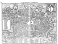 Cosmographie universelle 61803 Beauvais p375.png 10,056 × 7,624; 3.14 MB
-
 Diocèse de Beauvais - dressé par Charle ; gravé par Dumortier - btv1b84455681.jpg 9,154 × 7,129; 8.57 MB
-
 Plan Raymond Rancurelle - Beauvais 1572.jpg 4,495 × 3,277; 4.24 MB
-
 Plan V. Lhuillier, Beauvais en 1789, dressé en 1889, coll. SAO. 2.jpg 1,382 × 1,166; 971 KB
-
 Plan V. Lhuillier, Beauvais en 1789, dressé en 1889, coll. SAO.jpg 4,115 × 3,011; 3.48 MB
-

-
 Atlas ou Representation du Monde Universel t. 1. 1633 (109108783).jpg 17,126 × 11,814; 34.24 MB
Peyrounin_Abraham_btv1b8593235m_1.jpg)
.jpg)

.jpg)

.jpg)
.jpg)


.jpg)
.jpg)