
Category:Old maps of Aalst
Subcategories
This category has only the following subcategory.
Media in category "Old maps of Aalst"
The following 13 files are in this category, out of 13 total.
-
 Land Van Aalst, Belgium, by Jacques Horenbault in 1619.jpg 5,231 × 3,690; 4.3 MB
-
 Aalst.jpg 750 × 613; 234 KB
-
 Aalst, Belgium ; Ferraris Map.jpg 652 × 564; 55 KB
-
 Atlas buurtwegen, Aalst.jpg 831 × 643; 117 KB
-
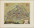 Atlas de Wit 1698-pl106-Aalst-KB PPN 145205088.jpg 2,000 × 1,647; 1.75 MB
-
 Guicciardini.jpg 5,512 × 3,801; 4.04 MB
-
 Inname van Aalst.JPG 1,500 × 1,014; 1,007 KB
-
 Land van Aalst, 1784, Leclerc.jpg 2,500 × 1,947; 1.11 MB
-
 Plattegrond Aalst Guicciardini 1581.jpg 500 × 331; 68 KB
-
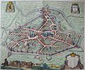 Sanderus.jpg 2,377 × 1,958; 1.06 MB
-
 Stadsplan, Gent, Brugge, Aalst, Oostende, Pieter Mortier.jpg 3,000 × 2,406; 4 MB
-
 Stadsplan, Gent, Brugge, Aalst, Oostende, Pieter Van Der Aa.jpg 2,634 × 1,937; 3.62 MB
-
 XXII 8 Alost.tif 6,106 × 7,709; 44.89 MB


