Category:Old School House, Hale
Jump to navigation
Jump to search
| Object location | | View all coordinates using: OpenStreetMap |
|---|
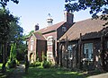
Grade II listed house in Hale, Halton, Cheshire, L24  | |||||
| Upload media | |||||
| Instance of |
| ||||
|---|---|---|---|---|---|
| Location | Hale, Halton, Cheshire, North West England, England | ||||
| Heritage designation |
| ||||
 | |||||
Built 1739 by William Part, a mariner, and refurbished and extended in 1875 by the Lord of the Manor Colonel John Ireland Blackburne. The original building is now a private residence and the 1875 extension a community centre.
Media in category "Old School House, Hale"
The following 4 files are in this category, out of 4 total.
-
 Old School House, Hale 2017-1.jpg 4,992 × 3,632; 10.61 MB
-
 Old School House, Hale 2017-2.jpg 4,933 × 3,523; 12.94 MB
-
 Old School House, Hale 2017.jpg 3,304 × 3,152; 6.12 MB
-
 Old School House, Hale.jpg 2,491 × 1,810; 1.06 MB


