Category:Old Roan station subway
Jump to navigation
Jump to search
| Object location | | View all coordinates using: OpenStreetMap |
|---|
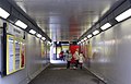
The subway is actually at ground level and is classed as an underline bridge, reference SJO2/15AA and is 5.78 miles from the datum at the former Liveroool Exchange station.
Media in category "Old Roan station subway"
The following 2 files are in this category, out of 2 total.
-
 Old Roan station subway 1.jpg 5,052 × 3,231; 9.19 MB
-
 Old Roan station subway 2.jpg 5,079 × 3,315; 9.52 MB

