Category:Old Portsmouth
Jump to navigation
Jump to search
English: Old Portsmouth is a suburb of Portsmouth, in the Portsmouth district, in the county of Hampshire, England.
area in Portsmouth, Hampshire, England  | |||||
| Upload media | |||||
| Instance of | |||||
|---|---|---|---|---|---|
| Location | Portsmouth, City of Portsmouth, Hampshire, South East England, England | ||||
 | |||||
Subcategories
This category has the following 17 subcategories, out of 17 total.
5
- 58 White Hart Road (7 F)
C
F
- Felton House, Old Portsmouth (4 F)
G
H
- Marjorie Henderson (2 F)
L
- Landport Gate, Portsmouth (4 F)
M
- Monks, Old Portsmouth (5 F)
O
P
S
Media in category "Old Portsmouth"
The following 200 files are in this category, out of 303 total.
(previous page) (next page)-
 1 Penny Street, Portsmouth.jpg 4,000 × 3,000; 5.59 MB
-
 1, 3 and 5 Lombard Street, Old Portsmouth (NHLE Code 1103826) (August 2022).JPG 1,800 × 1,800; 745 KB
-
 1-3 Battery Row - 52575278024.jpg 4,608 × 3,456; 14.01 MB
-
 1-5 Lombard Street, Portsmouth.jpg 4,608 × 3,456; 3.99 MB
-
 10 High Street, Old Portsmouth 2 - 52802532083.jpg 3,456 × 3,456; 9.13 MB
-
 11-13 Peacock Lane, Old Portsmouth.jpg 4,608 × 3,456; 4.09 MB
-
 11-17 Lombard Street, Old Portsmouth.jpg 4,000 × 3,000; 6.08 MB
-
 127-129 High Street, Old Portsmouth - 52693941422.jpg 4,000 × 3,000; 5.23 MB
-
 130-132, 132½ High Street, Old Portsmouth.jpg 4,000 × 3,000; 5.06 MB
-
 132, 132½ High Street, Old Portsmouth 2.jpg 4,000 × 3,000; 5.25 MB
-
 132, 132½ High Street, Old Portsmouth.jpg 4,000 × 3,000; 5.03 MB
-
 132½-134 High Street, and Braganza House, Old Portsmouth.jpg 4,000 × 3,000; 5.18 MB
-
 133 - 134, High St (geograph 6749162).jpg 1,024 × 706; 198 KB
-
 133, 134 High Street, and Braganza House.jpg 4,000 × 3,000; 5.35 MB
-
 14, Broad St - geograph.org.uk - 4316731.jpg 640 × 430; 54 KB
-
 16 High Street, Old Portsmouth.jpg 1,826 × 2,740; 1.32 MB
-
 19 Lombard Street - 52802529318.jpg 3,456 × 4,608; 4.92 MB
-
 22-23 High Street, Old Portsmouth - 52694459601.jpg 4,000 × 3,000; 5.37 MB
-
 22-23 High Street, Old Portsmouth 2 - 52694948108.jpg 4,000 × 3,000; 5.3 MB
-
 23-27 Lombard Street, Old Portsmouth.jpg 4,000 × 3,000; 6.02 MB
-
 27 Lombard Street, Old Portsmouth.jpg 1,360 × 2,400; 1.83 MB
-
 3 Penny Street, Portsmouth.jpg 4,000 × 3,000; 5.42 MB
-
 31-33 Penny Street, Old Portsmouth.jpg 4,608 × 3,456; 4.38 MB
-
 4-10 Lombard Street, Old Portsmouth.jpg 4,000 × 3,000; 5.03 MB
-
 47-51 Saint Thomas's Street, Old Portsmouth.jpg 4,608 × 3,456; 4.14 MB
-
 5-15 Lombard Street, OId Portsmouth.jpg 3,820 × 2,865; 5.34 MB
-
 51-52 Saint Thomas's Street, Old Portsmouth.jpg 3,456 × 4,608; 3.53 MB
-
 53 High Street, Old Portsmouth.jpg 3,456 × 4,608; 5.29 MB
-
 59–60 High Street, Old Portsmouth (NHLE Code 1333191) (August 2022).JPG 1,800 × 2,000; 1.07 MB
-
 6, 8, Broad St - geograph.org.uk - 4316732.jpg 640 × 430; 63 KB
-
 60-60a High Street, Old Portsmouth.jpg 3,456 × 4,608; 3.58 MB
-
 7-9 Peacock Lane, Old Portsmouth.jpg 3,456 × 4,608; 4.74 MB
-
 86-88 St Thomas's Street, OId Portsmouth.jpg 4,000 × 3,000; 4.93 MB
-

-
 A jetty in the Inner Camber - geograph.org.uk - 6381952.jpg 2,700 × 2,025; 453 KB
-
 A Plan of the Town and Fortifications of Portsmouth (1725).jpg 4,000 × 3,013; 1.63 MB
-

-

-
 America's Cup Headquarters Building - geograph.org.uk - 6140661.jpg 3,583 × 2,399; 1.27 MB
-
 Amusements on Clarence Pier - geograph.org.uk - 5523784.jpg 1,500 × 1,125; 202 KB
-
 An accurately located doorway - geograph.org.uk - 4478898.jpg 640 × 426; 57 KB
-
 Ashburton Rd - geograph.org.uk - 4474312.jpg 640 × 426; 78 KB
-
 Bath Square, Portsmouth - geograph.org.uk - 5843251.jpg 640 × 480; 94 KB
-
 Battery Row - geograph.org.uk - 2094971.jpg 640 × 427; 191 KB
-
 Battery Row - geograph.org.uk - 4316850.jpg 640 × 430; 66 KB
-
 Battery Row - geograph.org.uk - 4316852.jpg 640 × 430; 69 KB
-
 Beach at Southsea Hoverport - geograph.org.uk - 5981954.jpg 5,184 × 3,456; 6.4 MB
-
 Becket House, Peppercorn House, Old Portsmouth.jpg 4,608 × 3,456; 4.05 MB
-
 Boat passing Spice Island Inn - geograph.org.uk - 5981995.jpg 4,028 × 2,685; 629 KB
-
 Boats in the Inner Camber - geograph.org.uk - 6381945.jpg 2,700 × 2,025; 463 KB
-
 Brewers Fayre - geograph.org.uk - 6041466.jpg 1,024 × 681; 133 KB
-
 Broad Street bends into High Street, Portsmouth - geograph.org.uk - 6323779.jpg 1,024 × 768; 232 KB
-
 Broad Street, Portsmouth - geograph.org.uk - 6323763.jpg 1,024 × 768; 222 KB
-
 Buildings on Battery Row, Portsmouth - geograph.org.uk - 6323834.jpg 1,024 × 768; 215 KB
-
 Buildings, Grand Parade, Portsmouth - geograph.org.uk - 6323826.jpg 1,024 × 768; 245 KB
-
 Camber Dock, Portsmouth - geograph.org.uk - 6135496.jpg 3,995 × 2,996; 1.96 MB
-
 Cambridge Junction, Old Portsmouth.jpg 4,000 × 3,000; 5.27 MB
-

-
 Cat napping on substation Portsmouth UK 2018.jpg 3,936 × 5,248; 7.04 MB
-
 Cathedral church of St. Thomas - geograph.org.uk - 5647843.jpg 1,024 × 673; 198 KB
-
 Clarence Pier - geograph.org.uk - 6155738.jpg 3,960 × 2,640; 7.6 MB
-
 Clarence Pier Amusement Park - geograph.org.uk - 6196419.jpg 640 × 480; 72 KB
-
 Clarence Pier from the Solent - geograph.org.uk - 5619339.jpg 3,648 × 2,736; 2.55 MB
-
 Clarence Pier, Southsea - geograph.org.uk - 5833745.jpg 640 × 480; 48 KB
-
 Coastal path in Southsea - geograph.org.uk - 5571753.jpg 1,500 × 1,121; 226 KB
-
 Cobbled streets - geograph.org.uk - 4478915.jpg 640 × 426; 74 KB
-

-
 Completion of the Inaugural Phase of Millennium Promenade.jpg 2,264 × 2,264; 5.51 MB
-
 Contemplation of Pioneer statue, Portsmouth - geograph.org.uk - 6323700.jpg 1,024 × 768; 378 KB
-
 Cowdray engraving-full-lowres.jpg 750 × 250; 89 KB
-
 Demolition of the Old Fortifications at Portsmouth - ILN 1875.jpg 1,024 × 649; 390 KB
-
 Departing From Southsea - geograph.org.uk - 6155778.jpg 4,500 × 2,531; 7.68 MB
-
 Departing From Southsea - geograph.org.uk - 6155781.jpg 4,560 × 2,565; 7.59 MB
-
 Departing From Southsea - geograph.org.uk - 6155784.jpg 4,680 × 2,632; 7.69 MB
-
 Departing From Southsea - geograph.org.uk - 6155790.jpg 4,740 × 2,666; 7.64 MB
-
 Departing Portsmouth - geograph.org.uk - 6131021.jpg 5,040 × 2,835; 7.72 MB
-
 Dore's Court on Broad Street - geograph.org.uk - 4062802.jpg 1,500 × 999; 138 KB
-
 Duke of Buckingham - High Street - geograph.org.uk - 4437610.jpg 640 × 527; 65 KB
-
 Duke of Buckingham pub, Southsea.jpg 4,000 × 3,000; 6.2 MB
-
 Duke of Buckingham, Portsmouth - geograph.org.uk - 3024168.jpg 480 × 640; 67 KB
-
 East St - geograph.org.uk - 4316710.jpg 640 × 430; 53 KB
-
 East St - geograph.org.uk - 4478901.jpg 640 × 426; 57 KB
-
 Eat at Joe's - geograph.org.uk - 6134731.jpg 4,729 × 2,985; 1.81 MB
-
 Entering Portsmouth Harbour in fog - geograph.org.uk - 5595164.jpg 3,232 × 2,417; 1.06 MB
-
 Entrance to Game Over.jpg 4,608 × 3,456; 5.41 MB
-

-
 Fence near the Waterbus Terminal - geograph.org.uk - 6196376.jpg 640 × 480; 63 KB
-
 Flagship House, Old Portsmouth.jpg 4,000 × 3,000; 5.18 MB
-
 Flats at Gunwharf Quays - geograph.org.uk - 6228042.jpg 640 × 480; 60 KB
-
 Footbridge to the Long Curtain wall - geograph.org.uk - 6381955.jpg 2,700 × 2,015; 429 KB
-
 Former Gas Lamp Stands, Old Portsmouth.jpg 2,436 × 2,912; 3.84 MB
-
 Former Payne & Stevens, boot makers - 52575278489.jpg 3,456 × 4,608; 14.61 MB
-
 Formerly the Seagull, Portsmouth - geograph.org.uk - 6323459.jpg 1,024 × 1,024; 314 KB
-
 Formerly The Victoria Tavern - 52575450120.jpg 4,608 × 3,456; 14.78 MB
-
 Galleries in the West Curtain by Broad Street - geograph.org.uk - 6379684.jpg 2,700 × 2,025; 375 KB
-
 Georgian houses, Broad St - geograph.org.uk - 3200982.jpg 640 × 430; 59 KB
-
-
 Gosport Ferry Terminal - geograph.org.uk - 5520411.jpg 1,010 × 640; 137 KB
-
 Gosport, Waterfront panoramic (1 of 4) - geograph.org.uk - 5907025.jpg 1,024 × 683; 81 KB
-
 Gosport, Waterfront panoramic (2 of 4) - geograph.org.uk - 5907030.jpg 1,024 × 683; 102 KB
-
 Gosport, Waterfront panoramic (3 of 4) - geograph.org.uk - 5907038.jpg 1,024 × 683; 101 KB
-
 Gosport, Waterfront panoramic (4 of 4) - geograph.org.uk - 5907043.jpg 1,024 × 683; 108 KB
-
 Grand Parade, Portsmouth - geograph.org.uk - 5647848.jpg 1,024 × 768; 162 KB
-
 Gunwharf Rd - geograph.org.uk - 4478919.jpg 640 × 426; 64 KB
-
 High St, A3 - geograph.org.uk - 4316738.jpg 640 × 430; 73 KB
-

-
 High Street, Old Portsmouth - geograph.org.uk - 4055638.jpg 480 × 640; 342 KB
-
 High Street, Old Portsmouth, Hampshire - geograph.org.uk - 2170881.jpg 4,052 × 2,781; 3.64 MB
-
 Highbury Street is Narrow and Cobbled.jpg 4,000 × 3,000; 5.19 MB
-
 Hot Walls, Old Portsmouth.jpg 4,000 × 3,000; 5.08 MB
-
 Houses in Old Portsmouth - geograph.org.uk - 5136266.jpg 3,648 × 2,432; 2.7 MB
-
 Hovercraft near Clarence Esplanade - geograph.org.uk - 5981948.jpg 5,184 × 3,456; 5.67 MB
-
 Inside a building of Point Battery, Portsmouth - geograph.org.uk - 6323687.jpg 768 × 1,024; 203 KB
-
 Inside Game Over.jpg 4,608 × 3,456; 4.51 MB
-
 Isle of Wight-bound hovercraft enters Spithead - geograph.org.uk - 5519735.jpg 3,997 × 2,743; 2.52 MB
-
 Johnson's Fishmarket - geograph.org.uk - 3200974.jpg 640 × 430; 38 KB
-

-
 King Charles St - geograph.org.uk - 4478871.jpg 640 × 426; 65 KB
-
 King's Bastion - geograph.org.uk - 6041463.jpg 1,024 × 681; 137 KB
-
 King's Bastion - geograph.org.uk - 6041470.jpg 1,024 × 681; 161 KB
-
 King's Bastion Moat - geograph.org.uk - 6041468.jpg 1,024 × 681; 186 KB
-
 King's Bastion Moat - geograph.org.uk - 6041471.jpg 1,024 × 681; 169 KB
-
 Land Rover BAR Headquarters in Portsmouth - geograph.org.uk - 5571702.jpg 1,500 × 1,125; 153 KB
-
 Listed K6 Telephone Kiosk, Old Portsmouth.jpg 3,456 × 4,608; 6.59 MB
-
 Lombard St - geograph.org.uk - 4478652.jpg 426 × 640; 48 KB
-
 Lombard St - geograph.org.uk - 4478867.jpg 640 × 426; 69 KB
-
 Lombard Street - geograph.org.uk - 2277799.jpg 640 × 427; 192 KB
-
 Lombard Street - High Street - geograph.org.uk - 4437615.jpg 640 × 480; 77 KB
-
 Lombard Street, Old Portsmouth - geograph.org.uk - 3380090.jpg 800 × 589; 120 KB
-

-
 Looking to the Spinnaker Tower from Haslar sea wall - geograph.org.uk - 3426417.jpg 4,608 × 3,456; 3.26 MB
-
 Looking towards White Hart Road in 2012 - geograph.org.uk - 2990143.jpg 3,872 × 2,592; 4.27 MB
-
 Lunch at Clarence Pier - geograph.org.uk - 5838150.jpg 4,754 × 3,502; 1.78 MB
-
 Moat by the curtain wall on the King's Bastion - geograph.org.uk - 6381957.jpg 2,700 × 1,999; 403 KB
-
 Moat, King's Bastion, Portsmouth - geograph.org.uk - 6323805.jpg 1,024 × 768; 213 KB
-
 Multi-storey Boat Park Portsmouth - geograph.org.uk - 5502696.jpg 640 × 480; 90 KB
-
 MV Shetland Trader passing Gunwharf Quays - geograph.org.uk - 5997498.jpg 1,024 × 683; 178 KB
-
 MV Victoria of Wight - geograph.org.uk - 6193548.jpg 1,024 × 768; 138 KB
-
 Nelson Plaque from The George Inn.jpg 3,456 × 4,608; 4.03 MB
-
 Old buildings - geograph.org.uk - 5473144.jpg 1,024 × 697; 102 KB
-
 Old Portsmouth - geograph.org.uk - 2864707.jpg 800 × 526; 109 KB
-
 Old Portsmouth - geograph.org.uk - 731045.jpg 640 × 372; 49 KB
-
 Old Portsmouth RMG PV4700.jpg 1,280 × 915; 1.54 MB
-
 Old Portsmouth Waterfront - geograph.org.uk - 3564472.jpg 640 × 427; 215 KB
-
 Old Portsmouth Wideangle.jpg 4,819 × 2,453; 8.3 MB
-
 Old tram tracks, Portsmouth - geograph.org.uk - 6323324.jpg 1,024 × 684; 227 KB
-
 Old tram tracks, Portsmouth - geograph.org.uk - 6323327.jpg 1,024 × 768; 288 KB
-
 Old tramway switch blade, Portsmouth - geograph.org.uk - 6323380.jpg 768 × 1,024; 407 KB
-
 Old tramway turnout, Portsmouth - geograph.org.uk - 6323387.jpg 1,024 × 768; 375 KB
-

-
 Oyster Mews - geograph.org.uk - 4478876.jpg 640 × 426; 77 KB
-

-
 Peacock Cottage, Old Portsmouth.jpg 4,608 × 3,456; 3.99 MB
-
 Penny St - geograph.org.uk - 3201004.jpg 640 × 430; 59 KB
-
 Penny St - geograph.org.uk - 4474515.jpg 640 × 426; 63 KB
-
 Penny Street - geograph.org.uk - 2095260.jpg 640 × 426; 219 KB
-
-
 Penny Street, Old Portsmouth - geograph.org.uk - 3305018.jpg 1,600 × 1,181; 346 KB
-
 Pier by the Square Tower.jpg 4,000 × 3,000; 5.09 MB
-
 Pier Rd - geograph.org.uk - 4316899.jpg 640 × 430; 74 KB
-
 Pier Rd - geograph.org.uk - 4316903.jpg 640 × 430; 79 KB
-
 Pier Rd, A288 - geograph.org.uk - 4474340.jpg 640 × 426; 64 KB
-
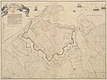
 Plan of the fortifications of the town of Portsmouth (c. 1660-1685).jpg 4,000 × 2,763; 1.56 MB
-
 Plaque at George Court - geograph.org.uk - 2095238.jpg 640 × 427; 199 KB
-
 Plaque for Portsmouth Main Guard House.jpg 4,608 × 3,456; 5.92 MB
-
 Point Battery and Old Portsmouth - geograph.org.uk - 4711169.jpg 640 × 380; 287 KB
-
 Point Battery, Portsmouth - geograph.org.uk - 6323562.jpg 1,024 × 768; 237 KB
-
 Point Battery, Portsmouth - geograph.org.uk - 6323671.jpg 1,024 × 768; 292 KB
-
 Point Steer, Portsmouth, or, the Coxwain Carousal (caricature) RMG PX8646.jpg 1,228 × 707; 685 KB
-
 Popinjay's Warehouse 3 - 52802478905.jpg 3,456 × 4,608; 5.55 MB
-
 Portsmouth - geograph.org.uk - 6156129.jpg 4,320 × 2,880; 7.8 MB
-
 Portsmouth - geograph.org.uk - 6175257.jpg 4,373 × 2,917; 7.76 MB
-
 Portsmouth - geograph.org.uk - 6175396.jpg 4,612 × 3,076; 7.58 MB
-

-
 Portsmouth Cathedral - geograph.org.uk - 4310512.jpg 640 × 430; 45 KB
-
 Portsmouth Cathedral - geograph.org.uk - 5982427.jpg 1,080 × 810; 158 KB
-

-
 Portsmouth Cathedral from the sea - geograph.org.uk - 4607824.jpg 640 × 427; 77 KB
-
 Portsmouth Harbour - geograph.org.uk - 4659435.jpg 2,666 × 4,000; 6.63 MB
-
 Portsmouth Harbour - geograph.org.uk - 4659442.jpg 2,666 × 4,000; 6.68 MB
-
 Portsmouth Harbour - geograph.org.uk - 6130998.jpg 4,680 × 2,632; 7.52 MB
-
 Portsmouth Harbour - geograph.org.uk - 6156192.jpg 4,140 × 2,760; 7.75 MB
-
 Portsmouth Harbour - geograph.org.uk - 6156203.jpg 4,020 × 2,680; 7.76 MB
-
 Portsmouth harbour as seen from gosport.jpg 3,508 × 2,556; 3 MB
-
 Portsmouth Point - geograph.org.uk - 6135490.jpg 3,375 × 2,396; 1.59 MB
-
 Portsmouth Sailing Club on Bath Square - geograph.org.uk - 5571685.jpg 1,125 × 1,500; 143 KB
-
 Portsmouth Seafront - geograph.org.uk - 3564525.jpg 640 × 481; 265 KB
-
 Portsmouth Seafront - geograph.org.uk - 3564600.jpg 640 × 481; 221 KB
-
 Portsmouth Waterfront - geograph.org.uk - 6157642.jpg 1,024 × 512; 190 KB
-
 Portsmouth, Gunwharf Road - geograph.org.uk - 3621912.jpg 640 × 480; 309 KB
-
 Portsmouth, Museum Road - geograph.org.uk - 3621906.jpg 640 × 480; 350 KB
-

-

-

-

-

-

-

-

-


_(August_2022).JPG)


.jpg)


_(August_2022).JPG)


.jpg)
.jpg)


_-_geograph.org.uk_-_5440668.jpg)

_-_geograph.org.uk_-_5907025.jpg)
_-_geograph.org.uk_-_5907030.jpg)
_-_geograph.org.uk_-_5907038.jpg)
_-_geograph.org.uk_-_5907043.jpg)


.jpg)


_RMG_PX8646.jpg)


_-_geograph.org.uk_-_6193590.jpg)


