Category:Old Chester Road bridge, Neston
Jump to navigation
Jump to search
| Object location | | View all coordinates using: OpenStreetMap |
|---|
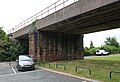
The name of this bridge is misleading but it's the one used by Network Rail; its many a year since any Chester Road ran near here. Its actuall on Station Road to the west of the site of the former Neston South station, demolished in 1964. There's also no bridge plate to confirm the details but this bridge carries the Borderlands Line over Station Road and the interrupted WIrral Way. It is numbered WDB3/32 and is 9.02 miles from the datum at Bidston. WBD3 is the Bidston Dee Junction to Dee Marsh West Junction line.
Media in category "Old Chester Road bridge, Neston"
The following 4 files are in this category, out of 4 total.
-
 Old Chester Road bridge, Neston 1.jpg 4,968 × 3,308; 8.38 MB
-
 Old Chester Road bridge, Neston 2.jpg 5,072 × 3,196; 8.63 MB
-
 Old Chester Road bridge, Neston 3.jpg 5,036 × 3,192; 9.6 MB
-
 Old Chester Road bridge, Neston 4.jpg 4,840 × 3,312; 8.11 MB


