Category:Okanagan shrub steppe
Jump to navigation
Jump to search
English: This is a collection of photos that best represent the Okanagan shrub-steppe ecosystem of the southern Okanagan region of British Columbia.
Media in category "Okanagan shrub steppe"
The following 19 files are in this category, out of 19 total.
-
 Abandoned Mini Golf Course - panoramio (2).jpg 2,560 × 1,440; 1 MB
-
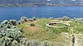 Base Ruins - panoramio.jpg 2,560 × 1,440; 1.26 MB
-
 Canada's only desert, Osoyoos - panoramio.jpg 1,600 × 1,200; 484 KB
-
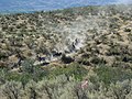
 Deer amidst the shrub-steppe of Osoyoos.jpg 4,800 × 2,696; 8.28 MB
-
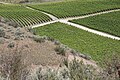 Desert terrain among Osoyoos Vineyard.jpg 4,288 × 2,848; 11 MB
-
 Looking Eastward over the Southern Okanagan Valley on a Spring Afternoon.JPG 4,485 × 2,803; 7.17 MB
-
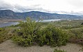
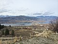
 Looking southeast at Lake Osoyoos.jpg 3,264 × 2,448; 2.04 MB
-
 Nk'mip Desert.JPG 640 × 480; 203 KB
-
 Nk'mipDesert.JPG 640 × 480; 203 KB
-
 Osoyoos Desert Centre Boardwalk.jpg 4,000 × 3,000; 5.39 MB
-
 Osoyoos, BC - panoramio.jpg 3,264 × 2,448; 2.72 MB
-
 Osoyoos-Tal - der wärmste Ort Kanadas inkl. Wüste (15901819667).jpg 4,608 × 3,072; 7.94 MB
-
 Shrubland-forest transition near Osoyoos.jpg 4,096 × 3,084; 2.55 MB
-
 Spirit Ridge - panoramio (2).jpg 1,280 × 853; 583 KB
-
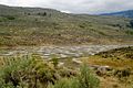
 Spotted Lake (4296724546).jpg 3,971 × 2,700; 6.72 MB
-
 Spotted Lake - panoramio (1).jpg 1,280 × 853; 743 KB
-
 Spotted Lake - panoramio (2).jpg 3,264 × 2,176; 4.01 MB
-
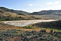 Spotted Lake Osoyoos.JPG 4,288 × 2,848; 3.11 MB
-
 Spotted Lake.jpg 3,264 × 2,448; 2.04 MB
.jpg)


.jpg)
.jpg)
.jpg)
.jpg)
.jpg)

