Category:Ohio State Route 64
Jump to navigation
Jump to search
 | number: | (sixty-four) |
|---|---|---|
| State highways in Ohio: | 44 · 45 · 46 · 47 · 48 · 49 · 51 · 53 · 54 · 55 · 56 · 57 · 58 · 59 · 60 · 61 · 63 · 64 · 65 · 66 · 67 · 72 · 73 · 78 · 79 · 81 · 82 · 83 · 84 |
highway in Ohio  | |||||
| Upload media | |||||
| Instance of | |||||
|---|---|---|---|---|---|
| Location | Ohio | ||||
| Transport network | |||||
| Owned by | |||||
| Maintained by | |||||
| Inception |
| ||||
| Length |
| ||||
| |||||
Media in category "Ohio State Route 64"
The following 9 files are in this category, out of 9 total.
-
 Findlay Street near rail line, Haskins.jpg 6,016 × 4,000; 7.12 MB
-
 Holy Trinity Catholic Church at Assumption.jpg 4,000 × 6,016; 6.24 MB
-
 Main west of Maple in Metamora, northern side.jpg 6,016 × 4,000; 6.85 MB
-
 Main west of Maple in Metamora, southern side.jpg 6,016 × 4,000; 6.19 MB
-
 Maple east of Swanton, Metamora.jpg 6,016 × 4,000; 6.35 MB
-
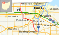 OH 64 map.svg 1,006 × 592; 646 KB
-
 OH-64.svg 600 × 600; 5 KB
-
 Providence from Waterville, Whitehouse.jpg 6,016 × 4,000; 6.4 MB
-
 Wooster Street in Boom Town.jpg 2,816 × 1,584; 1.43 MB


