Category:Ohio State Route 555
Jump to navigation
Jump to search
 | number: | (five hundred fifty-five) |
|---|---|---|
| State highways in Ohio: | 539 · 540 · 541 · 542 · 545 · 547 · 550 · 551 · 552 · 555 · 556 · 557 · 558 · 559 · 561 · 562 · 571 · 575 |
State highway in southeastern Ohio, US  | |||||
| Upload media | |||||
| Instance of | |||||
|---|---|---|---|---|---|
| Location | Ohio | ||||
| Transport network | |||||
| Owned by | |||||
| Maintained by | |||||
| Inception |
| ||||
| Length |
| ||||
| |||||
English: Media related to Ohio State Route 555.
Media in category "Ohio State Route 555"
The following 7 files are in this category, out of 7 total.
-
 Chesterhill, Marion at Mill.jpg 2,816 × 1,584; 1.08 MB
-
 Cutler overview from south.jpg 6,016 × 4,000; 6.36 MB
-
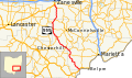 OH 555 map.svg 1,006 × 592; 749 KB
-
 OH-555.svg 750 × 600; 6 KB
-
 Pleasant Hill Methodist Church, Homer Township.jpg 2,816 × 2,112; 2.82 MB
-
 St. John's ELCA near Stovertown.jpg 2,112 × 2,816; 2.04 MB
-
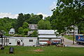
 Westward into Ringgold.jpg 2,816 × 1,584; 1.72 MB


