Category:Obergasse 26 (Alsfeld)
Jump to navigation
Jump to search
| Object location | | View all coordinates using: OpenStreetMap |
|---|
This is the category of the Hessian Kulturdenkmal (cultural monument) with the ID 13352 (Wikidata)
|
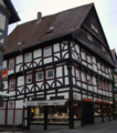
former hall house with later conversion into a half-timbered residential building at Obergasse 26 in Alsfeld, Vogelsbergkreis, Hesse, Germany  | |||||
| Upload media | |||||
| Instance of | |||||
|---|---|---|---|---|---|
| Part of | |||||
| Location | Alsfeld, Vogelsbergkreis, Giessen Government Region, Hesse, Germany | ||||
| Street address |
| ||||
| Heritage designation | |||||
| Inception |
| ||||
 | |||||
Media in category "Obergasse 26 (Alsfeld)"
The following 6 files are in this category, out of 6 total.
-
 Alsfeld Obergasse 26 13352.png 2,228 × 2,514; 8.34 MB
-
 Alsfeld Obergasse 26.jpg 4,000 × 6,000; 16.17 MB
-
 Alsfeld, Obergasse 26, Westseite-20160504-002.jpg 4,016 × 6,016; 11.51 MB
-
 Alsfeld, Obergasse 26-20160504-001.jpg 4,016 × 6,016; 13.24 MB
-
 Alsfeld, Obergasse 26-20160504-002.jpg 4,016 × 6,016; 13.67 MB
-
 Alsfeld, Obergasse 26-20160504-003.jpg 4,016 × 6,016; 12.63 MB


