Category:Oberer Mannenberg
Jump to navigation
Jump to search
| Object location | | View all coordinates using: OpenStreetMap |
|---|
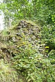
castle ruin in Zweisimmen in the canton of Bern, Switzerland  | |||||
| Upload media | |||||
| Instance of | |||||
|---|---|---|---|---|---|
| Part of | |||||
| Location | Zweisimmen, Obersimmental-Saanen administrative district, Oberland administrative region, Bern, Switzerland | ||||
| Street address |
| ||||
| Heritage designation | |||||
 | |||||
Media in category "Oberer Mannenberg"
The following 3 files are in this category, out of 3 total.
-
 Oberer Mannenberg - 1.jpg 6,048 × 4,032; 24.58 MB
-
 Oberer Mannenberg - 2.jpg 4,032 × 6,048; 26.59 MB
-
 Oberer Mannenberg - 3.jpg 6,048 × 4,032; 25.79 MB

