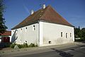
Category:Obere Mühle (Hirschau)
Jump to navigation
Jump to search
| Object location | | View all coordinates using: OpenStreetMap |
|---|
This is the category of the Bavarian Baudenkmal (cultural heritage monument) with the ID D-3-71-127-23 (Wikidata)
|
 | |||||
| Upload media | |||||
| Instance of | |||||
|---|---|---|---|---|---|
| Location | Hirschau, Amberg-Sulzbach, Upper Palatinate, Bavaria, Germany | ||||
| Street address |
| ||||
| Heritage designation | |||||
 | |||||
Media in category "Obere Mühle (Hirschau)"
This category contains only the following file.
-
 Hirschau Obere Mühle 001.JPG 3,568 × 2,404; 5.51 MB