Category:Obere Kapfenhardter Mühle
Jump to navigation
Jump to search
| Object location | | View all coordinates using: OpenStreetMap |
|---|
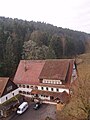
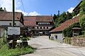
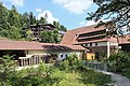
Mill in the Kapfenhardter valley, Germany  | |||||
| Upload media | |||||
| Instance of | |||||
|---|---|---|---|---|---|
| Location | Unterreichenbach, Calw District, Karlsruhe Government Region, Baden-Württemberg, Germany | ||||
 | |||||
Media in category "Obere Kapfenhardter Mühle"
The following 16 files are in this category, out of 16 total.
-
 Mühlelädle und Sound ^ Light Emotions - panoramio.jpg 3,072 × 2,015; 4.03 MB
-
 Obere Kapfenhardter Mühle 2.jpg 1,920 × 2,560; 1.09 MB
-
 Obere Kapfenhardter Mühle.jpg 2,507 × 1,564; 857 KB
-
 ObereKapfenhardterMühleNebengebäude.jpg 2,560 × 1,920; 1.1 MB
-
 Unterreichenbach - Zu den Mühlen + 6Obere Kapfenhardter Mühle 01 ies.jpg 5,616 × 3,743; 23.23 MB
-
 Unterreichenbach - Zu den Mühlen - 6Obere Kapfenhardter Mühle + Reichenbach 01 ies.jpg 5,616 × 3,744; 22.68 MB
-
 Unterreichenbach - Zu den Mühlen - 6Obere Kapfenhardter Mühle 01 ies.jpg 5,616 × 3,746; 21.65 MB
-
 Unterreichenbach - Zu den Mühlen - 6Obere Kapfenhardter Mühle 02 ies.jpg 5,616 × 3,744; 24.69 MB
-
 Unterreichenbach - Zu den Mühlen - 6Obere Kapfenhardter Mühle 03 ies.jpg 5,616 × 3,744; 26.6 MB
-
 Unterreichenbach - Zu den Mühlen - 6Obere Kapfenhardter Mühle 04 ies.jpg 5,616 × 3,744; 19.41 MB
-
 Unterreichenbach - Zu den Mühlen - 6Obere Kapfenhardter Mühle 05 ies.jpg 5,616 × 3,745; 18.87 MB
-
 Unterreichenbach - Zu den Mühlen - 6Obere Kapfenhardter Mühle 06 ies.jpg 5,616 × 3,745; 16.46 MB
-
 Unterreichenbach - Zu den Mühlen - 6Obere Kapfenhardter Mühle 07 ies.jpg 5,616 × 3,744; 24.16 MB
-
 Unterreichenbach - Zu den Mühlen - 6Obere Kapfenhardter Mühle 08 ies.jpg 5,616 × 3,744; 21.7 MB
-
 Unterreichenbach - Zu den Mühlen - 6Obere Kapfenhardter Mühle 09 ies.jpg 5,616 × 3,744; 25.37 MB
-
 Unterreichenbach - Zu den Mühlen - 6Obere Kapfenhardter Mühle 10 ies.jpg 5,616 × 3,744; 16.89 MB


