Category:Nunivak Island
Appearance
island in Bethel Census Area, Alaska, United States | |||||
| Upload media | |||||
| Instance of | |||||
|---|---|---|---|---|---|
| Location | Bering Sea | ||||
| Located in or next to body of water | |||||
| Time of discovery or invention |
| ||||
| Width |
| ||||
| Length |
| ||||
| Population |
| ||||
| Area |
| ||||
| Elevation above sea level |
| ||||
 | |||||
Subcategories
This category has the following 3 subcategories, out of 3 total.
M
- Maps of Nunivak Island (9 F)
- Mekoryuk, Alaska (5 F)
Q
- Qiviut (8 F)
Media in category "Nunivak Island"
The following 48 files are in this category, out of 48 total.
-
Anim2001.jpg 3,600 × 2,141; 759 KB
-
Ceremonial mask wearer Nunivak Curtis LOC.JPG 1,523 × 1,162; 141 KB
-
Children at reindeer roundup Nunivak 1964.jpg 1,050 × 837; 95 KB
-
Drummer Nunivak Curtis LOC.JPG 1,500 × 1,158; 179 KB
-
Duck-Skin Parkas, Nunivak LACMA AC1997.271.47 (cropped).jpg 1,229 × 1,577; 326 KB
-
Duck-Skin Parkas, Nunivak LACMA AC1997.271.47.jpg 1,514 × 2,100; 815 KB
-
DunesNunivakFWS.jpg 1,050 × 700; 63 KB
-
Edward S. Curtis Collection People 009.jpg 925 × 685; 443 KB
-
Edward S. Curtis Collection People 017.jpg 649 × 866; 356 KB
-
Edward S. Curtis Collection People 035.jpg 1,024 × 831; 141 KB
-
Edwards Boys Warming Up Mikisigimiut Bay Nunivak Island (6872064015).jpg 2,948 × 2,376; 1.22 MB
-
Fratercula corniculata.jpg 1,855 × 1,234; 899 KB
-
Ice and Clouds in the Bering Strait.jpg 5,600 × 4,200; 4.71 MB
-
Inuit kayak (Alaska) - Arctic Museum.jpg 3,022 × 946; 644 KB
-
Kaiaks Nelson.JPG 589 × 840; 61 KB
-
Kayak propelled with single-blade paddle.jpg 1,049 × 781; 80 KB
-
Musk ox pair (6565982995).jpg 4,932 × 3,284; 5.53 MB
-
Musk Ox.jpg 3,008 × 2,000; 2.38 MB
-
Muskox at Dahkit Cove, Nunivak Island (5284102600).jpg 4,827 × 3,060; 3.7 MB
-
Muskox on Nunivak Island, Alaska (8229637601).jpg 698 × 427; 61 KB
-
Muskox Up Close on Nunivak Island (4730695519).jpg 698 × 427; 41 KB
-
MuskOxen.jpg 528 × 128; 15 KB
-
NashHarborNunivakCurtisLOC3c07326v.jpg 3,579 × 2,453; 748 KB
-
Native Alaskan women black and white photo.jpg 2,100 × 1,686; 186 KB
-
Nunavik island.jpg 5,770 × 4,237; 2.72 MB
-
Nunivak 4 wheel ATV.jpg 3,072 × 2,304; 1.76 MB
-
Nunivak Island 1949 Western Alaska Family with Skin Kyak (6872060521).jpg 2,960 × 2,396; 666 KB
-
Nunivak Island abt 1949 Western Alaskan Family (6872061427).jpg 2,960 × 2,420; 1.29 MB
-
Nunivak Island Skin Covered Kyak circa 1949 (6872061897).jpg 2,440 × 2,984; 696 KB
-
Nunivak jump-rope.jpg 1,050 × 840; 190 KB
-
Nunivak kayaks NOAA line1688.jpg 1,796 × 1,172; 1.33 MB
-
Nunivak maskette.jpg 465 × 640; 38 KB
-
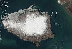
Nunivak MODIS.jpg 508 × 348; 42 KB
-
Nunivak tundra and lakes.jpg 3,072 × 2,304; 1.31 MB
-
NunivakCliffsFWS726.jpg 1,050 × 702; 667 KB
-
Ola Noatak by Edward S. Curtis, ca. 1927.jpg 1,081 × 1,496; 247 KB
-
Ovibos moschatus (Nunivak Island).jpg 3,008 × 2,000; 2.83 MB
-
People disembarking from the boat to shore while others help them.jpg 2,100 × 1,716; 151 KB
-
Ready for the throw Curtis LOC (cropped).JPG 1,358 × 1,013; 253 KB
-
Ready for the throw Curtis LOC.JPG 1,507 × 1,167; 137 KB
-
RoundupNunivak1964FWS.jpg 1,050 × 837; 162 KB
-
Sand dunes on Nunivak island.jpg 1,575 × 1,050; 50 KB
-
Sand Dunes on the Northern Coast of Nunivak Island.jpg 4,032 × 3,024; 1.69 MB
-
Ŭǵiyakŭ--Nunivak 3c01193v.jpg 829 × 1,024; 98 KB


