Category:November 2009 in Northern Ireland
Jump to navigation
Jump to search
English: Images taken in Northern Ireland in this month of 2009 (not the date of the upload).
| Jan | Feb | Mar | Apr | May | Jun | Jul | Aug | Sep | Oct | Nov | Dec | ||
| ← | 8 | 10 | 208 | 141 | 365 | 342 | 581 | 691 | 445 | 685 | 323 | 537 | → |
|---|
Subcategories
This category has the following 7 subcategories, out of 7 total.
A
- November 2009 in County Antrim (36 F)
B
- November 2009 in Belfast (16 F)
D
- November 2009 in County Down (34 F)
F
T
- November 2009 in County Tyrone (93 F)
Media in category "November 2009 in Northern Ireland"
The following 200 files are in this category, out of 316 total.
(previous page) (next page)-
 "Weir ahead" sign, Lisburn - geograph.org.uk - 1591945.jpg 640 × 372; 86 KB
-
 A gap in the field, Brackagh - geograph.org.uk - 1596166.jpg 640 × 480; 81 KB
-
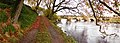 A panoramic view along the Strule - geograph.org.uk - 1565330.jpg 640 × 231; 53 KB
-
 A rainy day in High Street, Omagh - geograph.org.uk - 1588091.jpg 640 × 480; 65 KB
-
 A view across The Lagan , Lisburn - geograph.org.uk - 1590595.jpg 640 × 480; 82 KB
-
 A wet crossing, Omagh - geograph.org.uk - 1588086.jpg 640 × 480; 68 KB
-

-
 Annadale Avenue, Belfast - geograph.org.uk - 1574917.jpg 626 × 432; 94 KB
-
 Approaching Charlestown - geograph.org.uk - 1591683.jpg 640 × 480; 101 KB
-
-
 Armagh (01), November 2009.JPG 4,272 × 2,848; 4.5 MB
-
 Armagh (02), November 2009.JPG 4,272 × 2,848; 4.36 MB
-
 Armagh (03), November 2009.JPG 4,272 × 2,848; 3.59 MB
-
 Armagh Indian Nights, November 2009.JPG 4,272 × 2,848; 4.03 MB
-
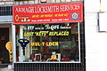 Armagh Locksmith Services, November 2009.JPG 4,272 × 2,848; 3.93 MB
-
 Armagh Omniplex, November 2009.JPG 4,272 × 2,848; 4.19 MB
-
 Ashmount Gardens, Lisburn - geograph.org.uk - 1591926.jpg 640 × 360; 74 KB
-
 Autumnal sunset at Lisburn Station - geograph.org.uk - 1570859.jpg 640 × 480; 78 KB
-
 B95, Hillhead Road - geograph.org.uk - 1586733.jpg 640 × 480; 40 KB
-
 B95, The Burn Road - geograph.org.uk - 1586569.jpg 640 × 480; 73 KB
-
 Back Entry, Belfast - geograph.org.uk - 1578098.jpg 640 × 456; 274 KB
-
 Back of the Eisenhower Pier, Bangor - geograph.org.uk - 1592987.jpg 640 × 385; 232 KB
-
 Bannfoot Road approaching the ferry - geograph.org.uk - 1591632.jpg 640 × 480; 114 KB
-
 Barnardos, Armagh, November 2009.JPG 4,272 × 2,848; 4.29 MB
-
 Barrack Street, Armagh (01), November 2009.JPG 4,272 × 2,848; 5.08 MB
-
 Bedford Street, Belfast - geograph.org.uk - 1593917.jpg 640 × 480; 57 KB
-
 Bedford Street, Belfast - geograph.org.uk - 1593975.jpg 640 × 480; 66 KB
-
 Belmont Bowling Club, Belfast - geograph.org.uk - 1595374.jpg 640 × 314; 72 KB
-
 Bennetts Photo Shop, Armagh, November 2009.JPG 4,272 × 2,848; 4.59 MB
-
 Berries (1), Omagh - geograph.org.uk - 1566533.jpg 640 × 480; 38 KB
-
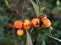 Berries (2), Omagh - geograph.org.uk - 1566535.jpg 640 × 480; 37 KB
-
 Birthplace of Father Francis Kelly - geograph.org.uk - 1579846.jpg 640 × 479; 96 KB
-
 Blood Transfusion offices, Belfast - geograph.org.uk - 1599807.jpg 640 × 382; 86 KB
-
 Boer War Memorial, Omagh - geograph.org.uk - 1593462.jpg 640 × 480; 149 KB
-
 Boots, Armagh, November 2009.JPG 4,272 × 2,848; 3.82 MB
-
 Boyd Street, Belfast (1) - geograph.org.uk - 1582948.jpg 640 × 440; 94 KB
-
 Boyd Street, Belfast (2) - geograph.org.uk - 1582970.jpg 640 × 380; 107 KB
-
 Brackagh Townland - geograph.org.uk - 1596156.jpg 640 × 480; 56 KB
-
 Brackagh Townland - geograph.org.uk - 1596160.jpg 640 × 480; 51 KB
-
 Bridge Street, Omagh - geograph.org.uk - 1588159.jpg 640 × 480; 66 KB
-
 British Heart Foundation, Armagh, November 2009.JPG 2,848 × 4,272; 4.99 MB
-
 Brown Square, Belfast - geograph.org.uk - 1582887.jpg 640 × 400; 93 KB
-
 Buildings along James Street, Omagh - geograph.org.uk - 1588121.jpg 640 × 480; 47 KB
-
 Bus stop, Belfast - geograph.org.uk - 1576611.jpg 640 × 436; 96 KB
-
 Cadogan Street, Belfast - geograph.org.uk - 1593582.jpg 640 × 480; 56 KB
-
 Cancer Research, Armagh, November 2009.JPG 4,272 × 2,848; 5.34 MB
-
 Carved figure, Camphill (1) - geograph.org.uk - 1579786.jpg 479 × 640; 182 KB
-
 Carved figure, Camphill (2) - geograph.org.uk - 1579793.jpg 479 × 640; 178 KB
-
 Carved figure, Camphill (3) - geograph.org.uk - 1579801.jpg 479 × 640; 189 KB
-
 Carved figure, Camphill (3) - geograph.org.uk - 1579810.jpg 479 × 640; 198 KB
-
 Carved figure, Camphill (4) - geograph.org.uk - 1579828.jpg 479 × 640; 173 KB
-
 Cathedral Close, Armagh (01), November 2009.JPG 4,272 × 2,848; 4.55 MB
-
 Cathedral Close, Armagh (02), November 2009.JPG 4,272 × 2,848; 3.37 MB
-
 Cathedral Close, Armagh (04), November 2009.JPG 4,272 × 2,848; 3.82 MB
-
 Cathedral Close, Armagh (05), November 2009.JPG 4,272 × 2,848; 6.16 MB
-
 Cathedral Close, Armagh (06), November 2009.JPG 4,272 × 2,848; 4.52 MB
-
 Cathedral Gardens, Armagh (01), November 2009.JPG 4,272 × 2,848; 6.39 MB
-
 Cathedral Gardens, Armagh (02), November 2009.JPG 4,272 × 2,848; 5.31 MB
-
 Cathedral Gardens, Armagh (03), November 2009.JPG 2,848 × 4,272; 6.35 MB
-
 Cattle feeding, Clanabogan - geograph.org.uk - 1578143.jpg 640 × 479; 63 KB
-
 Causeway to Rough Island (4) - geograph.org.uk - 1567267.jpg 640 × 415; 83 KB
-
 Celtic Cross, Armagh (01), November 2009.JPG 4,272 × 2,848; 4.1 MB
-
 Celtic Cross, Armagh (02), November 2009.JPG 2,848 × 4,272; 4.64 MB
-
 ChapelofUnity.jpg 640 × 350; 60 KB
-
 Chichi Rascals, Armagh, November 2009.JPG 4,272 × 2,848; 3.96 MB
-
 Church House, Armagh (01), November 2009.JPG 4,272 × 2,848; 5.8 MB
-
 Church House, Armagh (02), November 2009.JPG 2,848 × 4,272; 6.48 MB
-
 Church House, Armagh (03), November 2009.JPG 4,272 × 2,848; 6.51 MB
-
 Church House, Armagh (04), November 2009.JPG 2,848 × 4,272; 4.75 MB
-
 Clanabogan Road, Clanabogan Upper - geograph.org.uk - 1578134.jpg 640 × 479; 65 KB
-
 Clanabogan Townland - geograph.org.uk - 1578160.jpg 640 × 479; 60 KB
-
 Clanabogan Townland - geograph.org.uk - 1578164.jpg 640 × 479; 70 KB
-
 Clanabogan Upper - geograph.org.uk - 1578131.jpg 640 × 479; 82 KB
-
 Clanabogan Upper - geograph.org.uk - 1578135.jpg 640 × 479; 61 KB
-
 Clanabogan Upper - geograph.org.uk - 1578139.jpg 640 × 479; 81 KB
-
 Clarke Decorate, Armagh, November 2009.JPG 4,272 × 2,848; 4.32 MB
-
 Clonallon Gardens, Belfast - geograph.org.uk - 1595292.jpg 640 × 333; 80 KB
-
 Clonallon Square, Belfast - geograph.org.uk - 1595338.jpg 640 × 346; 86 KB
-

-

-
 Cow on a hill - geograph.org.uk - 1578136.jpg 640 × 479; 51 KB
-
 Crock Townland - geograph.org.uk - 1575926.jpg 640 × 480; 41 KB
-
 Crock Townland - geograph.org.uk - 1575930.jpg 640 × 480; 63 KB
-
 Crossroads, Clanabogan - geograph.org.uk - 1578167.jpg 640 × 479; 70 KB
-
 Crucknamona Road, Clanabogan - geograph.org.uk - 1578130.jpg 640 × 479; 77 KB
-
 Crucknamona Road, Clanabogan - geograph.org.uk - 1578161.jpg 640 × 479; 83 KB
-
 Crucknamona Road, Drudgeon - geograph.org.uk - 1578337.jpg 640 × 479; 68 KB
-
 Cyclamen (01), November 2009.JPG 4,272 × 2,848; 3.26 MB
-
 Cyclamen (02), November 2009.JPG 4,272 × 2,848; 3.15 MB
-
 Cycle stand, Omagh - geograph.org.uk - 1588080.jpg 640 × 480; 68 KB
-
 Decorbrite, Armagh, November 2009.JPG 4,272 × 2,848; 4.51 MB
-
 Derelict bungalow, Clanabogan - geograph.org.uk - 1578166.jpg 640 × 479; 65 KB
-
 Doorway and plaque, Belfast - geograph.org.uk - 1566118.jpg 640 × 410; 98 KB
-
 Downpatrick cloud, November 2009.JPG 4,272 × 2,848; 2.86 MB
-
 Drudgeon Road, Drudgeon - geograph.org.uk - 1578341.jpg 640 × 479; 63 KB
-
 Drumragh Avenue, Omagh - geograph.org.uk - 1593452.jpg 640 × 480; 129 KB
-
 Dudley Street, Belfast (2) - geograph.org.uk - 1599985.jpg 579 × 509; 108 KB
-
 DV8, Armagh, November 2009.JPG 4,272 × 2,848; 3.48 MB
-
 Ebrington Gardens, Belfast (1) - geograph.org.uk - 1594675.jpg 640 × 361; 82 KB
-
 Erne River at the Clinton Centre - geograph.org.uk - 1599368.jpg 640 × 480; 114 KB
-
 Ewarts Jewellers, Armagh, November 2009.JPG 4,272 × 2,848; 4.47 MB
-
 Exit road, City Hospital, Belfast - geograph.org.uk - 1599865.jpg 640 × 297; 69 KB
-
 Exit, Tyrone County Hospital - geograph.org.uk - 1581894.jpg 640 × 479; 59 KB
-
 Fallen leaves, Castle Park - geograph.org.uk - 1579570.jpg 524 × 640; 614 KB
-
 Fanlight, Belfast (2) - geograph.org.uk - 1599541.jpg 640 × 423; 86 KB
-
 Fanlight, Belfast (3) - geograph.org.uk - 1599556.jpg 640 × 396; 81 KB
-
 Fern, Cranny - geograph.org.uk - 1581902.jpg 640 × 479; 121 KB
-
 Flanagans butchers, Armagh, November 2009.JPG 4,272 × 2,848; 4.86 MB
-
 Flooded field, Garvaghy Big Hill - geograph.org.uk - 1596237.jpg 640 × 480; 57 KB
-
 Flooded path, Cranny - geograph.org.uk - 1569129.jpg 640 × 480; 96 KB
-
 Flooding, Mountjoy Road, Omagh - geograph.org.uk - 1081372.jpg 404 × 640; 48 KB
-
 Foundry Lane, Omagh - geograph.org.uk - 1588104.jpg 640 × 480; 67 KB
-
 Friary Road, Armagh (01), November 2009.JPG 4,272 × 2,848; 4.72 MB
-
 Friary Road, Armagh (02), November 2009.JPG 4,272 × 2,848; 4.69 MB
-
 Friary Road, Armagh (03), November 2009.JPG 4,272 × 2,848; 3.43 MB
-
 Friary Road, Armagh (04), November 2009.JPG 4,272 × 2,848; 4.68 MB
-
 Gadget and Gift Store, Omagh - geograph.org.uk - 1566528.jpg 640 × 480; 70 KB
-
 Garvaghey Road - geograph.org.uk - 1596227.jpg 640 × 480; 83 KB
-
 Garvaghy Big Hill - geograph.org.uk - 1596240.jpg 640 × 480; 66 KB
-
 Garvaghy Road, Garvaghy - geograph.org.uk - 1596224.jpg 640 × 480; 59 KB
-
 Garvaghy Townland - geograph.org.uk - 1596233.jpg 640 × 480; 91 KB
-
 Garvaghyhill Road, Garvaghy - geograph.org.uk - 1596234.jpg 640 × 480; 50 KB
-
 Gordons Chemists, Armagh, November 2009.JPG 4,272 × 2,848; 4.73 MB
-
 Graffiti at Tintown - geograph.org.uk - 1565387.jpg 640 × 480; 58 KB
-
 Grassy path, Camphill - geograph.org.uk - 1579819.jpg 640 × 479; 98 KB
-
-
 Great Victoria Street, Belfast - geograph.org.uk - 1593855.jpg 480 × 640; 76 KB
-
 Greencastle Livestock Sales - geograph.org.uk - 1576061.jpg 640 × 480; 68 KB
-
 Hattys insurance brokers, Armagh, November 2009.JPG 4,272 × 2,848; 4.13 MB
-
 Hawthornes, Armagh (01), November 2009.JPG 2,848 × 4,272; 4.68 MB
-
 Hawthornes, Armagh (02), November 2009.JPG 4,272 × 2,848; 4.88 MB
-
 Hawthornes, Armagh (03), November 2009.JPG 4,272 × 2,848; 4.93 MB
-
 Hawthornes, Armagh, November 2009.JPG 4,272 × 2,848; 4.93 MB
-
 Horse, Cranny - geograph.org.uk - 1581911.jpg 640 × 479; 83 KB
-
 Hospital Road, Omagh - geograph.org.uk - 1581890.jpg 640 × 479; 81 KB
-
 Hotel extension, Belfast (13) - geograph.org.uk - 1582701.jpg 609 × 473; 101 KB
-
 Hotel extension. Belfast (14) - geograph.org.uk - 1582725.jpg 640 × 459; 85 KB
-
 Houses at Garvaghy - geograph.org.uk - 1596230.jpg 640 × 480; 60 KB
-
 Interior, Sally's, Omagh - geograph.org.uk - 1057510.jpg 640 × 480; 53 KB
-
 Irish National Foresters, Armagh, November 2009.JPG 4,272 × 2,848; 4.15 MB
-
 Irishtown Road, Omagh - geograph.org.uk - 1588075.jpg 640 × 480; 59 KB
-
 Irwin Crescent, Belfast (2) - geograph.org.uk - 1594720.jpg 640 × 495; 129 KB
-
 ISA Man, Omagh - geograph.org.uk - 1588143.jpg 640 × 480; 82 KB
-
 Jogging near the Lovers Retreat - geograph.org.uk - 1581900.jpg 640 × 479; 99 KB
-
 John Street, Omagh - geograph.org.uk - 1588111.jpg 640 × 480; 64 KB
-
 John Street, Omagh - geograph.org.uk - 1588152.jpg 640 × 480; 67 KB
-
 Johnstons Home Bakery, Armagh, November 2009.JPG 4,272 × 2,848; 3.83 MB
-
 Kesh Bridge, Balteagh - geograph.org.uk - 1591416.jpg 640 × 480; 153 KB
-
 Kevlin Avenue, Omagh - geograph.org.uk - 1588096.jpg 640 × 480; 57 KB
-
 Kevlin Avenue, Omagh - geograph.org.uk - 1588098.jpg 640 × 480; 62 KB
-
 Kevlin Road, Omagh - geograph.org.uk - 1565376.jpg 640 × 480; 56 KB
-
 Kevlin Road, Omagh - geograph.org.uk - 1565383.jpg 640 × 480; 63 KB
-
 Killyclogher Burn in flood - geograph.org.uk - 1569128.jpg 640 × 480; 110 KB
-
 Lane, Clanabogan - geograph.org.uk - 1578140.jpg 640 × 479; 82 KB
-
 Leafy path, Camphill - geograph.org.uk - 1579832.jpg 640 × 479; 110 KB
-
 Leaves and path, Castle Park - geograph.org.uk - 1579577.jpg 640 × 420; 506 KB
-
 Lilas, Armagh, November 2009.JPG 4,272 × 2,848; 5.41 MB
-
 Linenhall Street, Armagh (01), November 2009.JPG 4,272 × 2,848; 5.53 MB
-
 Linenhall Street, Armagh (02), November 2009.JPG 4,272 × 2,848; 4.52 MB
-
 Loughmacrory Road - geograph.org.uk - 1569259.jpg 640 × 480; 66 KB
-
 Loughmacrory Road - geograph.org.uk - 1569262.jpg 640 × 480; 73 KB
-
 Loughmacrory Road, Loughmacrory - geograph.org.uk - 1569255.jpg 640 × 480; 78 KB
-
 Market Place, Armagh (01), November 2009.JPG 4,272 × 2,848; 4.61 MB
-
 Market Place, Armagh (02), November 2009.JPG 4,272 × 2,848; 3.66 MB
-
 Market Street, Armagh (01), November 2009.JPG 4,272 × 2,848; 5.01 MB
-
 Market Street, Armagh (02), November 2009.JPG 800 × 533; 102 KB
-
 Market Street, Armagh (04), November 2009.JPG 4,272 × 2,848; 4.14 MB
-
 Market Street, Armagh (05), November 2009.JPG 4,272 × 2,848; 4.47 MB
-
 Market Street, Armagh (06), November 2009.JPG 4,272 × 2,848; 3.84 MB
-
 Market Yard, Omagh - geograph.org.uk - 1588180.jpg 640 × 480; 70 KB
-
 McCrums Court, Armagh, November 2009.JPG 2,848 × 4,272; 3.46 MB
-
 Memorial plaque, Tyrone County Hospital - geograph.org.uk - 1581893.jpg 640 × 479; 100 KB
-
 Memorial stone, Drudgeon Road - geograph.org.uk - 1579851.jpg 640 × 479; 98 KB
-
 Methodist College, Belfast - geograph.org.uk - 1599923.jpg 640 × 382; 126 KB
-
 Millennium Seat, Cranny - geograph.org.uk - 1581906.jpg 640 × 479; 104 KB
-
 Millfield Tech, Belfast - geograph.org.uk - 1582999.jpg 640 × 344; 63 KB
-

-
 Moving house and in no hurry, Omagh - geograph.org.uk - 1583844.jpg 640 × 412; 61 KB
-
 Muddy gate entrance, Brackagh - geograph.org.uk - 1596163.jpg 640 × 480; 58 KB
-
 Mullan Terrace, Omagh - geograph.org.uk - 1588115.jpg 640 × 480; 50 KB
-
 Mural, Belfast - geograph.org.uk - 1593835.jpg 640 × 480; 45 KB
-
 Near Loughmacrory - geograph.org.uk - 1569261.jpg 640 × 480; 71 KB
-
 New building, Lisburn Road, Belfast - geograph.org.uk - 1599774.jpg 640 × 404; 71 KB
-

-
 Nirvana, Armagh, November 2009.JPG 2,848 × 4,272; 3.97 MB
-
 No 15 Upper Crescent, Belfast (2) - geograph.org.uk - 1596742.jpg 640 × 398; 112 KB
-
 No 15 Upper Crescent, Belfast - geograph.org.uk - 1596728.jpg 640 × 426; 94 KB
-

-
 Northern Bank, Armagh (01), November 2009.JPG 2,848 × 4,272; 3.87 MB
-
 Northern Bank, Armagh (02), November 2009.JPG 2,848 × 4,272; 3.8 MB
-
 OMA X Factor - geograph.org.uk - 1588764.jpg 640 × 291; 37 KB
-
 Omagh Bus Station - geograph.org.uk - 1593469.jpg 640 × 480; 120 KB
-

-
 Omagh Golf Course, Dergmoney Upper - geograph.org.uk - 1596276.jpg 640 × 480; 60 KB
-
 Owenkillew Credit Union, Greencastle - geograph.org.uk - 1576058.jpg 640 × 480; 38 KB
-
 Owenkillew River - geograph.org.uk - 1575749.jpg 640 × 480; 57 KB
-
 Path, Comber - geograph.org.uk - 1567441.jpg 640 × 380; 77 KB
-
 Pathway, Cranny - geograph.org.uk - 1581904.jpg 640 × 479; 96 KB
-
 Patrick's Fold, Armagh (01), November 2009.JPG 4,272 × 2,848; 4.69 MB
-
 Patrick's Fold, Armagh (02), November 2009.JPG 2,848 × 4,272; 4.5 MB


_-_geograph.org.uk_-_1575905.jpg)


,_Omagh_-_geograph.org.uk_-_1565393.jpg)
,_November_2009.JPG)
,_November_2009.JPG)
,_November_2009.JPG)


,_November_2009.JPG)


,_Omagh_-_geograph.org.uk_-_1566533.jpg)
,_Omagh_-_geograph.org.uk_-_1566535.jpg)


_-_geograph.org.uk_-_1582948.jpg)
_-_geograph.org.uk_-_1582970.jpg)


_-_geograph.org.uk_-_1579786.jpg)
_-_geograph.org.uk_-_1579793.jpg)
_-_geograph.org.uk_-_1579801.jpg)
_-_geograph.org.uk_-_1579810.jpg)
_-_geograph.org.uk_-_1579828.jpg)
,_November_2009.JPG)
,_November_2009.JPG)
,_November_2009.JPG)
,_November_2009.JPG)
,_November_2009.JPG)
,_November_2009.JPG)
,_November_2009.JPG)
,_November_2009.JPG)

_-_geograph.org.uk_-_1567267.jpg)
,_November_2009.JPG)
,_November_2009.JPG)


,_November_2009.JPG)
,_November_2009.JPG)
,_November_2009.JPG)
,_November_2009.JPG)


_-_geograph.org.uk_-_1576582.jpg)
_-_geograph.org.uk_-_1586960.jpg)


,_November_2009.JPG)
,_November_2009.JPG)


_-_geograph.org.uk_-_1599985.jpg)

_-_geograph.org.uk_-_1594675.jpg)


_-_geograph.org.uk_-_1599541.jpg)
_-_geograph.org.uk_-_1599556.jpg)


,_November_2009.JPG)
,_November_2009.JPG)
,_November_2009.JPG)
,_November_2009.JPG)


,_November_2009.JPG)
,_November_2009.JPG)
,_November_2009.JPG)


_-_geograph.org.uk_-_1582701.jpg)
_-_geograph.org.uk_-_1582725.jpg)


_-_geograph.org.uk_-_1594720.jpg)


,_November_2009.JPG)
,_November_2009.JPG)


,_November_2009.JPG)
,_November_2009.JPG)
,_November_2009.JPG)
,_November_2009.JPG)
,_November_2009.JPG)
,_November_2009.JPG)
,_November_2009.JPG)


_-_geograph.org.uk_-_1596742.jpg)


,_November_2009.JPG)
,_November_2009.JPG)


,_November_2009.JPG)
,_November_2009.JPG)