Category:North Foreland Lighthouse
Jump to navigation
Jump to search
| Object location | | View all coordinates using: OpenStreetMap |
|---|
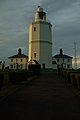
English: North Foreland
lighthouse at North Foreland, England  | |||||
| Upload media | |||||
| Instance of | |||||
|---|---|---|---|---|---|
| Made from material | |||||
| Location | North Foreland, Broadstairs and St Peter's, Thanet, Kent, South East England, England | ||||
| Has use | |||||
| Operator | |||||
| Heritage designation |
| ||||
| Inception |
| ||||
| Significant event |
| ||||
| Height |
| ||||
 | |||||
Media in category "North Foreland Lighthouse"
The following 31 files are in this category, out of 31 total.
-
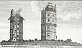
 North Foreland Lighthouse 1884.jpg 1,614 × 1,047; 656 KB
-
 Admiralty Chart No 1607 Thames Estuary Southern Part, Published 1967.jpg 14,926 × 8,420; 41.66 MB
-
 Cabbages and North Foreland Lighthouse - geograph.org.uk - 2654457.jpg 1,024 × 680; 270 KB
-
 Cabbages and North Foreland Lighthouse - geograph.org.uk - 2654461.jpg 680 × 1,024; 275 KB
-
-
 Crickaeth Castle, Caernarvonshire. (p.1167).jpeg 512 × 900; 301 KB
-
 Footpath to North Foreland Lighthouse - geograph.org.uk - 2402206.jpg 3,027 × 2,232; 1.58 MB
-

-
 Joss Bay near Kingsgate - geograph.org.uk - 185446.jpg 640 × 480; 87 KB
-
 Kingsgate-castle.jpg 3,805 × 2,864; 6.18 MB
-
 North Foreland Light Signal (FI W(5) 20s) Red Sector.gif 200 × 200; 19 KB
-
 North Foreland Lighthouse (48929551263).jpg 3,888 × 5,184; 3.19 MB
-
 North Foreland Lighthouse - geograph.org.uk - 1411373.jpg 640 × 426; 80 KB
-
 North Foreland Lighthouse - geograph.org.uk - 1474079.jpg 640 × 430; 115 KB
-
 North Foreland Lighthouse - geograph.org.uk - 1475564.jpg 640 × 323; 32 KB
-
 North Foreland Lighthouse - geograph.org.uk - 2402191.jpg 3,072 × 2,304; 1.59 MB
-
 North Foreland lighthouse - geograph.org.uk - 2592521.jpg 640 × 480; 40 KB
-
 North Foreland Lighthouse - geograph.org.uk - 2654467.jpg 1,024 × 680; 128 KB
-
 North Foreland Lighthouse - geograph.org.uk - 3260020.jpg 1,500 × 984; 175 KB
-
 North Foreland Lighthouse - geograph.org.uk - 39652.jpg 640 × 480; 59 KB
-
 North Foreland Lighthouse - geograph.org.uk - 518581.jpg 640 × 426; 115 KB
-
 North Foreland Lighthouse - geograph.org.uk - 518899.jpg 640 × 426; 100 KB
-
 North Foreland Lighthouse about 1880.jpg 993 × 1,025; 406 KB
-
 North Foreland Lighthouse aerial.jpg 3,872 × 2,592; 7.25 MB
-
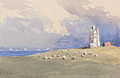 North Foreland Lighthouse by George Jackson.jpg 1,920 × 1,249; 716 KB
-
 North Foreland Lighthouse.PNG 603 × 704; 763 KB
-

-
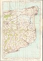 Ordnance Survey One-Inch Sheet 117 East Kent, Published 1920.jpg 8,603 × 12,090; 35.28 MB
-
 Sheep and lighthouse - geograph.org.uk - 2709419.jpg 640 × 480; 82 KB
-
 Sunset at North Foreland - geograph.org.uk - 2051169.jpg 2,336 × 3,504; 1.86 MB
-
 The North Foreland Lighthouse - geograph.org.uk - 518570.jpg 426 × 640; 153 KB


_cropped_(N_Foreland_Lighthouse).jpg)
.jpeg)


_20s)_Red_Sector.gif)
.jpg)


Categories:
- Lighthouses in England by name
- Grade II listed lighthouses in Kent
- Lighthouses built in 1691
- Lighthouses by height, 21 to 30 meters
- Stone lighthouses in the United Kingdom
- Octagonal lighthouses
- Octagonal buildings in England
- Trinity House lighthouses
- Built in England in 1691
- North Foreland
- Integral lighthouses
- Lighthouses by range, 15 to 19 nm
- Landfall lights in the United Kingdom