Category:North Down Borough Council
Jump to navigation
Jump to search
administrative territorial entity of the United Kingdom  | |||||
| Upload media | |||||
| Instance of |
| ||||
|---|---|---|---|---|---|
| Location | Ards and North Down, Northern Ireland | ||||
| Capital | |||||
| Area |
| ||||
| Religion or worldview | |||||
| official website | |||||
 | |||||
Subcategories
This category has only the following subcategory.
B
Media in category "North Down Borough Council"
The following 149 files are in this category, out of 149 total.
-
 Arrival at Bangor station - geograph.org.uk - 1732783.jpg 629 × 362; 84 KB
-
 Autumn at Crawfordsburn - geograph.org.uk - 1544539.jpg 640 × 383; 120 KB
-
 Autumn in Ward Park - geograph.org.uk - 1024670.jpg 640 × 480; 359 KB
-
 Autumn in Ward Park - geograph.org.uk - 1024674.jpg 640 × 480; 332 KB
-
 Beverley Hills, Bangor - geograph.org.uk - 1393206.jpg 640 × 451; 383 KB
-
 Bridge, Crawfordsburn Country Park - geograph.org.uk - 784721.jpg 640 × 412; 126 KB
-
 Bryans Burn, Bangor - geograph.org.uk - 790370.jpg 640 × 480; 540 KB
-
 Bus stop, Bangor - geograph.org.uk - 1732613.jpg 640 × 461; 59 KB
-
 Caravans near Groomsport - geograph.org.uk - 894033.jpg 640 × 367; 59 KB
-
 Chequered board, Bangor - geograph.org.uk - 930406.jpg 640 × 267; 25 KB
-
 Church of SS Philip and James - geograph.org.uk - 1617814.jpg 640 × 480; 84 KB
-
 Cockatiel, Ward Park - geograph.org.uk - 1217464.jpg 595 × 640; 367 KB
-
 Conifers, Cairn Wood near Belfast (1) - geograph.org.uk - 1592387.jpg 640 × 438; 102 KB
-

-
 Dilapidated bandstand, Bangor - geograph.org.uk - 1631534.jpg 640 × 480; 96 KB
-
 Drumhirk Townland - geograph.org.uk - 1721569.jpg 3,648 × 2,736; 2.11 MB
-
 Edward VII postbox, Holywood - geograph.org.uk - 837852.jpg 420 × 640; 217 KB
-

-
 Entrance to Glenbank - geograph.org.uk - 930407.jpg 640 × 480; 48 KB
-
 Fallen leaves, Ward Park - geograph.org.uk - 1021285.jpg 640 × 568; 442 KB
-
 Field and tree near Bangor - geograph.org.uk - 803178.jpg 640 × 480; 255 KB
-

-
 Fine houses, Bangor - geograph.org.uk - 971274.jpg 640 × 419; 218 KB
-
 First Holywood Presbyterian Church - geograph.org.uk - 1618630.jpg 640 × 480; 47 KB
-
 Footbridge, Crawfordsburn - geograph.org.uk - 1159505.jpg 640 × 382; 128 KB
-

-
-

-
 Fungus, Clandeboye Wood (11) - geograph.org.uk - 967791.jpg 640 × 465; 106 KB
-
 Fungus, Crawfordsburn Glen (14) - geograph.org.uk - 937582.jpg 605 × 450; 99 KB
-
 Fungus, Helen's Bay (2) - geograph.org.uk - 947410.jpg 637 × 403; 83 KB
-
 Fungus, Helen's Bay (3) - geograph.org.uk - 947471.jpg 640 × 353; 91 KB
-
 Fungus, Helen's Bay (4) - geograph.org.uk - 947499.jpg 568 × 389; 87 KB
-
 Fungus, Helen's Bay (5) - geograph.org.uk - 947644.jpg 552 × 485; 98 KB
-
 Fungus, Helen's Bay (6) - geograph.org.uk - 947670.jpg 640 × 391; 95 KB
-
 Fungus, Helen's Bay (6) - geograph.org.uk - 958997.jpg 502 × 398; 93 KB
-
 Fungus, Helen's Bay (7) - geograph.org.uk - 947689.jpg 540 × 396; 105 KB
-
 Glenganagh, near Bangor (2) - geograph.org.uk - 802587.jpg 640 × 443; 264 KB
-
 Graffiti, Bangor - geograph.org.uk - 1161024.jpg 640 × 480; 248 KB
-
 Greylag geese, Ward Park - geograph.org.uk - 1056935.jpg 640 × 635; 326 KB
-
 Holywood Motte - geograph.org.uk - 837886.jpg 640 × 480; 331 KB
-
 Late harvest near Six Road Ends - geograph.org.uk - 995368.jpg 640 × 424; 274 KB
-
 Late harvest near Six Road Ends - geograph.org.uk - 995375.jpg 640 × 440; 381 KB
-

-

-
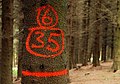 Marked tree, Cairn Wood near Belfast - geograph.org.uk - 1592526.jpg 640 × 447; 98 KB
-
 Meadowvale Avenue, Bangor - geograph.org.uk - 735236.jpg 640 × 480; 43 KB
-
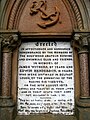 Memorial, Holywood (detail) - geograph.org.uk - 837831.jpg 480 × 640; 295 KB
-
 Memorial, Holywood - geograph.org.uk - 837828.jpg 469 × 640; 264 KB
-
 Milestone, Ulster Folk Museum - geograph.org.uk - 1107561.jpg 640 × 480; 467 KB
-
 Moira Drive, Bangor - geograph.org.uk - 1629262.jpg 640 × 474; 264 KB
-
 Moira Drive, Bangor - geograph.org.uk - 1629264.jpg 640 × 480; 275 KB
-
 Monument, Holywood - geograph.org.uk - 1618609.jpg 640 × 480; 63 KB
-
 North Down 1993 Abbey highlight.svg 562 × 220; 131 KB
-
 North Down 1993 Ballyholme and Groomsport highlight.svg 562 × 220; 131 KB
-
 North Down 1993 Bangor West highlight.svg 562 × 220; 131 KB
-
 North Down 1993 Holywood highlight.svg 562 × 220; 131 KB
-
 Old Belfast Road, Bangor (1) - geograph.org.uk - 756867.jpg 640 × 480; 136 KB
-
 Old Belfast Road, Bangor (2) - geograph.org.uk - 756870.jpg 480 × 640; 91 KB
-
 Old Priory, Holywood - geograph.org.uk - 1618602.jpg 480 × 640; 102 KB
-

-
 Old Railway Timetable. - geograph.org.uk - 1222279.jpg 640 × 480; 74 KB
-
 Old wall, Crawfordsburn Country Park - geograph.org.uk - 1159657.jpg 640 × 428; 130 KB
-
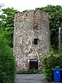 Old windmill, Holywood - geograph.org.uk - 841420.jpg 480 × 640; 459 KB
-
 Parish Centre, Holywood - geograph.org.uk - 1617808.jpg 640 × 480; 66 KB
-
 Path and river, Crawfordsburn - geograph.org.uk - 1159475.jpg 617 × 371; 106 KB
-
 Path by Twisel Burn, Holywood - geograph.org.uk - 841416.jpg 640 × 480; 535 KB
-
 Path, Cairn Wood near Belfast (1) - geograph.org.uk - 1592394.jpg 574 × 371; 95 KB
-
 Path, Cairn Wood near Belfast (2) - geograph.org.uk - 1592409.jpg 610 × 358; 105 KB
-
 Path, Crawfordsbsurn Country Park - geograph.org.uk - 1501926.jpg 624 × 384; 130 KB
-
 Pine trees, Bangor - geograph.org.uk - 833406.jpg 638 × 640; 306 KB
-
 Pipeline warning sign, Seahill - geograph.org.uk - 720797.jpg 640 × 480; 33 KB
-
 Plaque, Brice Park - geograph.org.uk - 1393210.jpg 640 × 392; 403 KB
-
 Postbox, Bangor - geograph.org.uk - 1619488.jpg 537 × 640; 391 KB
-
 Postbox, Bangor - geograph.org.uk - 1619531.jpg 640 × 480; 437 KB
-
 Postbox, Bangor - geograph.org.uk - 1619543.jpg 480 × 640; 392 KB
-
 Postbox, Bangor - geograph.org.uk - 1619550.jpg 497 × 640; 312 KB
-
 Primroses, Crawfordsburn Glen - geograph.org.uk - 767900.jpg 640 × 415; 63 KB
-
 Priory and graveyard, Holywood - geograph.org.uk - 1618604.jpg 640 × 480; 43 KB
-

-
 Railway line, Seahill - geograph.org.uk - 749777.jpg 640 × 490; 251 KB
-
 Railway path, Bangor (1) - geograph.org.uk - 1733064.jpg 608 × 369; 94 KB
-
 Railway path, Bangor (2) - geograph.org.uk - 1733102.jpg 609 × 366; 92 KB
-
 Ranfurly Avenue, Bangor - geograph.org.uk - 1445607.jpg 640 × 480; 85 KB
-
 Rollo House, Holywood - geograph.org.uk - 1618589.jpg 640 × 480; 44 KB
-

-
 Shops, Groomsport Road, Bangor (1) - geograph.org.uk - 738731.jpg 640 × 480; 69 KB
-
 Shops, Groomsport Road, Bangor (2) - geograph.org.uk - 738734.jpg 640 × 496; 68 KB
-
 Shops, Groomsport Road, Bangor (3) - geograph.org.uk - 738737.jpg 640 × 515; 72 KB
-
 Shops, Groomsport Road, Bangor (4) - geograph.org.uk - 738741.jpg 640 × 522; 73 KB
-
 Sign, Ballyholme Beach - geograph.org.uk - 1161046.jpg 579 × 640; 243 KB
-
 Sign, Cairn Wood near Belfast - geograph.org.uk - 1592381.jpg 640 × 446; 135 KB
-
 Sir Edward Bingham Mural, Kilcooley - geograph.org.uk - 1607261.jpg 640 × 480; 75 KB
-
 Sluice gate, Ward Park (detail) - geograph.org.uk - 1024681.jpg 640 × 480; 274 KB
-
 Small pier near Pickie, Bangor - geograph.org.uk - 846795.jpg 640 × 480; 275 KB
-
 Small waterfall, Stricklands Glen - geograph.org.uk - 1033397.jpg 473 × 640; 348 KB
-
 Snow on the Coastal Path, Bangor - geograph.org.uk - 1631217.jpg 640 × 480; 99 KB
-
 Speed Camera, Holywood (2) - geograph.org.uk - 735226.jpg 566 × 640; 73 KB
-
 Spring sycamore, Crawfordsburn - geograph.org.uk - 767925.jpg 640 × 473; 66 KB
-
 Springwell Road near Groomsport - geograph.org.uk - 735240.jpg 640 × 480; 55 KB
-
 Stricklands Glen, Bangor (1) - geograph.org.uk - 711405.jpg 640 × 490; 129 KB
-
 Stricklands Glen, Bangor (2) - geograph.org.uk - 711413.jpg 640 × 480; 111 KB
-

-
 The 'Pickie Swans' at dusk - geograph.org.uk - 1770169.jpg 640 × 425; 242 KB
-
 The Ballyrobert Road near Crawfordsburn - geograph.org.uk - 1503610.jpg 640 × 387; 100 KB
-
 The Bangor Road near Groomsport - geograph.org.uk - 1769896.jpg 640 × 423; 256 KB
-
 The Belfast Road, Bangor - geograph.org.uk - 1732585.jpg 629 × 390; 88 KB
-
 The Crawfordsburn, Crawfordsburn (2) - geograph.org.uk - 1544488.jpg 636 × 361; 116 KB
-
 The Crawfordsburn, Crawfordsburn - geograph.org.uk - 1366004.jpg 558 × 368; 108 KB
-

-

-
 The shore at Crawfordsburn (1) - geograph.org.uk - 785019.jpg 640 × 436; 72 KB
-
 The shore at Crawfordsburn (2) - geograph.org.uk - 785026.jpg 640 × 424; 92 KB
-
 The Silverbirch Road, Bangor - geograph.org.uk - 235365.jpg 640 × 426; 120 KB
-
 The Ulster Folk Museum (13) - geograph.org.uk - 515422.jpg 640 × 426; 96 KB
-
 The Ulster Folk Museum (14) - geograph.org.uk - 515427.jpg 640 × 426; 115 KB
-
 The Ulster Folk Museum (15) - geograph.org.uk - 515434.jpg 640 × 426; 80 KB
-
 The Ulster Folk Museum (16) - geograph.org.uk - 515439.jpg 640 × 426; 74 KB
-
 The Ulster Folk Museum (18) - geograph.org.uk - 515449.jpg 640 × 426; 62 KB
-
 The Ulster Folk Museum (19) - geograph.org.uk - 515459.jpg 640 × 426; 98 KB
-
 The Ulster Folk Museum (20) - geograph.org.uk - 515467.jpg 640 × 426; 61 KB
-
 The Ulster Folk Museum (22) - geograph.org.uk - 515480.jpg 640 × 426; 79 KB
-
 The Ulster Folk Museum (23) - geograph.org.uk - 515491.jpg 640 × 426; 93 KB
-
 The Ulster Folk Museum (24) - geograph.org.uk - 515497.jpg 640 × 426; 70 KB
-
 The Ulster Folk Museum (26) - geograph.org.uk - 515507.jpg 640 × 426; 99 KB
-
 Track near Bangor (1) - geograph.org.uk - 803167.jpg 640 × 480; 281 KB
-
 Track near Bangor (2) - geograph.org.uk - 803170.jpg 640 × 480; 285 KB
-

-
 Tree stump, Ward Park - geograph.org.uk - 1024031.jpg 480 × 640; 376 KB
-
 Trees and river, Ward Park - geograph.org.uk - 992694.jpg 640 × 454; 285 KB
-
 Trees near Pickie, Bangor - geograph.org.uk - 717962.jpg 532 × 600; 112 KB
-
 Twisel Bridge, Holywood - geograph.org.uk - 840397.jpg 640 × 580; 518 KB
-
 Twisel Burn, Holywood - geograph.org.uk - 841413.jpg 640 × 480; 550 KB
-
 Two sheughs, Cairn Wood near Belfast - geograph.org.uk - 1592490.jpg 626 × 355; 114 KB
-
 Unusually high tide, Ballyholme - geograph.org.uk - 658568.jpg 640 × 480; 69 KB
-
 Victoria House, Holywood - geograph.org.uk - 1618640.jpg 640 × 480; 48 KB
-
 Victoria Road, Holywood - geograph.org.uk - 837849.jpg 548 × 640; 389 KB
-
 View of Groomsport - geograph.org.uk - 531557.jpg 640 × 480; 56 KB
-
 Ward Park - geograph.org.uk - 1056933.jpg 640 × 635; 387 KB
-
 Ward Park in the snow - geograph.org.uk - 1629265.jpg 640 × 480; 322 KB
-
 Ward Park in the snow - geograph.org.uk - 1629266.jpg 640 × 480; 287 KB
-
 Warning sign, Bangor - geograph.org.uk - 1720288.jpg 640 × 475; 225 KB
-
 Weathervane, Bangor - geograph.org.uk - 567790.jpg 640 × 426; 75 KB
-
 Whin bush, Grey Point (1) - geograph.org.uk - 776502.jpg 640 × 536; 315 KB
-
 Whin bush, Grey Point (2) - geograph.org.uk - 776503.jpg 640 × 609; 405 KB
-
 Winter on the Coastal Path, Bangor - geograph.org.uk - 1631532.jpg 640 × 480; 131 KB
-
 Woodland fungus near Conlig - geograph.org.uk - 539805.jpg 640 × 426; 81 KB
-
 Woodland near Conlig - geograph.org.uk - 547847.jpg 640 × 426; 118 KB
-
 Woodland path - geograph.org.uk - 547970.jpg 640 × 426; 120 KB


_-_geograph.org.uk_-_1592387.jpg)
_-_geograph.org.uk_-_1592509.jpg)


_-_geograph.org.uk_-_1501645.jpg)
_-_geograph.org.uk_-_1501827.jpg)

_-_geograph.org.uk_-_967791.jpg)
_-_geograph.org.uk_-_937582.jpg)
_-_geograph.org.uk_-_947410.jpg)
_-_geograph.org.uk_-_947471.jpg)
_-_geograph.org.uk_-_947499.jpg)
_-_geograph.org.uk_-_947644.jpg)
_-_geograph.org.uk_-_947670.jpg)
_-_geograph.org.uk_-_958997.jpg)
_-_geograph.org.uk_-_947689.jpg)
_-_geograph.org.uk_-_802587.jpg)


_-_geograph.org.uk_-_1592444.jpg)
_-_geograph.org.uk_-_1592461.jpg)


_-_geograph.org.uk_-_837831.jpg)


_-_geograph.org.uk_-_756867.jpg)
_-_geograph.org.uk_-_756870.jpg)


_-_geograph.org.uk_-_1592394.jpg)
_-_geograph.org.uk_-_1592409.jpg)


_-_geograph.org.uk_-_1733064.jpg)
_-_geograph.org.uk_-_1733102.jpg)


_-_geograph.org.uk_-_751640.jpg)
_-_geograph.org.uk_-_738731.jpg)
_-_geograph.org.uk_-_738734.jpg)
_-_geograph.org.uk_-_738737.jpg)
_-_geograph.org.uk_-_738741.jpg)


_-_geograph.org.uk_-_1024681.jpg)


_-_geograph.org.uk_-_735226.jpg)


_-_geograph.org.uk_-_711405.jpg)
_-_geograph.org.uk_-_711413.jpg)


_-_geograph.org.uk_-_1544488.jpg)


_-_geograph.org.uk_-_785019.jpg)
_-_geograph.org.uk_-_785026.jpg)

_-_geograph.org.uk_-_515422.jpg)
_-_geograph.org.uk_-_515427.jpg)
_-_geograph.org.uk_-_515434.jpg)
_-_geograph.org.uk_-_515439.jpg)
_-_geograph.org.uk_-_515449.jpg)
_-_geograph.org.uk_-_515459.jpg)
_-_geograph.org.uk_-_515467.jpg)
_-_geograph.org.uk_-_515480.jpg)
_-_geograph.org.uk_-_515491.jpg)
_-_geograph.org.uk_-_515497.jpg)
_-_geograph.org.uk_-_515507.jpg)
_-_geograph.org.uk_-_803167.jpg)
_-_geograph.org.uk_-_803170.jpg)


_-_geograph.org.uk_-_776502.jpg)
_-_geograph.org.uk_-_776503.jpg)


