Category:Niklaus-Thut-Brunnen (Niklaus-Thut-Platz, Zofingen)
Jump to navigation
Jump to search
| Object location | | View all coordinates using: OpenStreetMap |
|---|
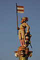
flowing well fountain in Zofingen in the canton of Aargau, Switzerland  | |||||
| Upload media | |||||
| Instance of |
| ||||
|---|---|---|---|---|---|
| Part of | |||||
| Location | Zofingen, Zofingen District, Aargau, Switzerland | ||||
| Street address |
| ||||
| Architectural style | |||||
| Heritage designation | |||||
| Inception |
| ||||
 | |||||
Media in category "Niklaus-Thut-Brunnen (Niklaus-Thut-Platz, Zofingen)"
The following 5 files are in this category, out of 5 total.
-

-
 Zofingen Niklaus Thut-Brunnen 02.jpg 2,736 × 1,824; 1.61 MB
-
 Zofingen Niklaus Thut-Brunnen 03.jpg 2,736 × 1,824; 1.69 MB
-
 Zofingen Niklaus Thut-Brunnen.jpg 2,736 × 1,824; 1.51 MB
-
 Zofingen-Thut-Brunnen.jpg 800 × 1,200; 104 KB
_Mattes_2022-07-30.jpg)


