Category:Night in West Dunbartonshire
Jump to navigation
Jump to search
Media in category "Night in West Dunbartonshire"
The following 43 files are in this category, out of 43 total.
-
 5pm rush hour on Great Western Road - geograph.org.uk - 661857.jpg 640 × 480; 46 KB
-
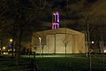
 Abbotsford Church, Clydebank at night - geograph.org.uk - 735537.jpg 640 × 480; 61 KB
-
 Agamemnon Street, Dalmuir - geograph.org.uk - 688998.jpg 640 × 480; 59 KB
-

-
 Back view of houses on Kilbowie Road - geograph.org.uk - 652121.jpg 640 × 480; 72 KB
-
 Bus stop on Kilbowie Road - geograph.org.uk - 735563.jpg 640 × 480; 62 KB
-
 Bus stop on Kilbowie Road - geograph.org.uk - 771906.jpg 640 × 480; 74 KB
-

-
 Car park behind Clyde shopping centre - geograph.org.uk - 735558.jpg 640 × 480; 66 KB
-
 Clyde Shopping Centre - geograph.org.uk - 735549.jpg 640 × 480; 55 KB
-
 Clydebank Abbotsford Church - geograph.org.uk - 735541.jpg 640 × 480; 90 KB
-
 Clydebank by night (11894204314).jpg 1,024 × 683; 624 KB
-
 Clydebank nightshoot (12058846625).jpg 1,024 × 683; 420 KB
-
 Clydebank nightshoot (12058857105).jpg 1,024 × 683; 375 KB
-
 Clydebank nightshoot (12059145363).jpg 1,024 × 683; 442 KB
-
 Clydebank nightshoot (12059242374).jpg 1,024 × 683; 414 KB
-
 Clydebank nightshoot (12059724316).jpg 1,024 × 683; 420 KB
-
 Clydebank Town Hall - geograph.org.uk - 579559.jpg 640 × 480; 61 KB
-
 Dusk view over Kilpatrick Hills - geograph.org.uk - 682668.jpg 640 × 480; 34 KB
-
 Harris Crescent, Old Kilpatrick - geograph.org.uk - 667435.jpg 640 × 480; 72 KB
-
 Housing on Oronsay Crescent - geograph.org.uk - 667437.jpg 640 × 480; 65 KB
-
 Kilbowie Road at Dumbarton Road - geograph.org.uk - 660000.jpg 640 × 480; 84 KB
-
 Kilbowie Road at night - geograph.org.uk - 667447.jpg 640 × 480; 79 KB
-
 Kilbowie Road, Clydebank - geograph.org.uk - 735560.jpg 640 × 480; 58 KB
-
 Kilbowie Road, Clydebank town centre - geograph.org.uk - 668575.jpg 640 × 480; 80 KB
-
 Lights on Hume Street - geograph.org.uk - 1082000.jpg 640 × 480; 124 KB
-

-
 Looking south on Kilbowie Road - geograph.org.uk - 667452.jpg 640 × 480; 61 KB
-
 Looking towards Clyde shopping centre - geograph.org.uk - 668572.jpg 640 × 480; 64 KB
-

-
 Night view of Clydebank centre - geograph.org.uk - 735545.jpg 640 × 480; 51 KB
-
 Night view of Kilbowie Road - geograph.org.uk - 667500.jpg 640 × 480; 106 KB
-
 Red sky at sunset, Kilbowie Road - geograph.org.uk - 1096669.jpg 640 × 480; 111 KB
-
 Singer railway station at night.jpg 640 × 480; 66 KB
-
 Sutherland Road, Clydebank - geograph.org.uk - 735555.jpg 640 × 480; 66 KB
-
 The Atlantis Bar, Kilbowie Road - geograph.org.uk - 735569.jpg 640 × 480; 105 KB
-

-
 Three Queens Square, Clydebank - geograph.org.uk - 735543.jpg 640 × 480; 56 KB
-
 Trees and night sky over Mountblow - geograph.org.uk - 661863.jpg 640 × 480; 61 KB
-
 Trig station in Goldenhill Park - geograph.org.uk - 771884.jpg 640 × 480; 67 KB
-
-
 View south on Kilbowie Road - geograph.org.uk - 771913.jpg 640 × 480; 58 KB
-
 Walkway under Kilbowie Road - geograph.org.uk - 667482.jpg 640 × 480; 68 KB


.jpg)
.jpg)
.jpg)
.jpg)
.jpg)
.jpg)


