Category:Nieuwstadskerk
Jump to navigation
Jump to search
| Object location | | View all coordinates using: OpenStreetMap |
|---|
church building in Zutphen, Netherlands  | |||||
| Upload media | |||||
| Instance of | |||||
|---|---|---|---|---|---|
| Location | Zutphen, Gelderland, Netherlands | ||||
| Street address |
| ||||
| Located on street |
| ||||
| Heritage designation |
| ||||
| Inception |
| ||||
| Religion or worldview | |||||
 | |||||
Nederlands: Nieuwstadskerk - anno 13e eeuw
|
This is a category about rijksmonument number 41371
|
| Address |
|
Subcategories
This category has the following 2 subcategories, out of 2 total.
R
T
Media in category "Nieuwstadskerk"
The following 56 files are in this category, out of 56 total.
-
 20150617 Zutphen met Nieuwstadskerktoren.jpg 4,896 × 3,672; 2.12 MB
-
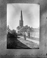
 De Nieuwstadskerk met toren te Zutphen - Zutphen - 20226905 - RCE.jpg 2,038 × 2,694; 1.72 MB
-

-
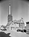
 De Nieuwstadskerk te Zutphen naar het noord-westen - Zutphen - 20226906 - RCE.jpg 2,586 × 2,068; 1.62 MB
-
 De Nieuwstadskerk te Zutphen.jpg 5,329 × 6,779; 28.12 MB
-
 De Nieuwstadskerk te Zutphen2.jpg 6,059 × 4,718; 21.22 MB
-

-

-

-

-
 Het zuid-portaal van de Nieuwstadskerk te Zutphen - Zutphen - 20226910 - RCE.jpg 844 × 1,200; 203 KB
-

-

-

-

-

-

-

-

-

-
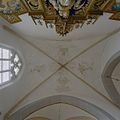
 Interieur, overzicht richting het koor - Zutphen - 20352823 - RCE.jpg 1,200 × 1,117; 191 KB
-
 Interieur, overzicht richting het oosten - Zutphen - 20373640 - RCE.jpg 1,200 × 1,200; 227 KB
-

-
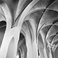
 Interieur, overzicht zuider zijbeuk richting het westen - Zutphen - 20351890 - RCE.jpg 1,200 × 1,195; 209 KB
-

-

-
-
 Interieur, zuider zijbeuk, Maria-altaar - Zutphen - 20352828 - RCE.jpg 1,191 × 1,200; 211 KB
-
 Interieur, zuider zijbeuk, Maria-altaar - Zutphen - 20352829 - RCE.jpg 1,200 × 1,198; 254 KB
-
 Interieur, zuider zijbeuk, Maria-altaar, detail - Zutphen - 20352830 - RCE.jpg 1,200 × 1,196; 383 KB
-

-
 Kruisbeeld in de Nieuwstadskerk te Zutphen - Zutphen - 20226921 - RCE.jpg 932 × 1,200; 139 KB
-
 Kruisbeeld in de Nieuwstadskerk te Zutphen - Zutphen - 20226923 - RCE.jpg 935 × 1,200; 266 KB
-
 Monstrans in de Nieuwstadskerk te Zutphen - Zutphen - 20226922 - RCE.jpg 960 × 1,200; 166 KB
-

-
-

-

-

-

-
 Noordgevel, bouwspoor van voormalige toegang - Zutphen - 20335190 - RCE.jpg 1,200 × 1,200; 444 KB
-

-

-
 Overzicht noordoost gevel met omgeving - Zutphen - 20366583 - RCE.jpg 941 × 1,200; 161 KB
-

-
 Overzicht oostgevel met zicht op de kerktoren - Zutphen - 20373633 - RCE.jpg 1,200 × 1,196; 195 KB
-
 Overzicht van de noordoostzijde van de kerk - Zutphen - 20420408 - RCE.jpg 794 × 1,200; 134 KB
-
 Overzicht van de zuidoostzijde van de kerk - Zutphen - 20420409 - RCE.jpg 806 × 1,200; 170 KB
-
 Overzicht zuidgevel - Zutphen - 20373638 - RCE.jpg 1,200 × 1,200; 356 KB
-
-
-
 Schilderij "Doortocht door de Rode Zee" - Zutphen - 20226916 - RCE.jpg 1,200 × 959; 275 KB
-
 Schilderij in de Nieuwstadskerk te Zutphen - Zutphen - 20226924 - RCE.jpg 1,200 × 933; 290 KB
-

-

-
 Zilveren kruisbeeld - Zutphen - 20226915 - RCE.jpg 2,141 × 2,695; 1,024 KB


_-_Zutphen_-_20226977_-_RCE.jpg)


_van_de_Nieuwstadskerk_te_Zutphen_-_Zutphen_-_20226955_-_RCE.jpg)


