Category:Nieuwegracht 5, Utrecht
Jump to navigation
Jump to search
| Object location | | View all coordinates using: OpenStreetMap |
|---|
 | |||||
| Upload media | |||||
| Instance of |
| ||||
|---|---|---|---|---|---|
| Location | Utrecht, Netherlands | ||||
| Street address |
| ||||
| Located on street | |||||
| Heritage designation |
| ||||
 | |||||
|
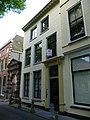
This is a category about rijksmonument number 36384
|
| Address |
|
Media in category "Nieuwegracht 5, Utrecht"
The following 3 files are in this category, out of 3 total.
-
 Nieuwegracht 5.JPG 2,592 × 3,456; 4.16 MB
-
 Nieuwegracht-Oost, 3512 Utrecht, Netherlands - panoramio (7).jpg 3,888 × 2,592; 1.63 MB
-
 Overzicht - Utrecht - 20236074 - RCE.jpg 803 × 1,200; 192 KB
.jpg)
