Category:Nieuwegracht 36, Utrecht
Jump to navigation
Jump to search
| Object location | | View all coordinates using: OpenStreetMap |
|---|
 | |||||
| Upload media | |||||
| Instance of | |||||
|---|---|---|---|---|---|
| Location | Utrecht, Netherlands | ||||
| Street address |
| ||||
| Located on street | |||||
| Heritage designation |
| ||||
 | |||||
|
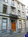
This is a category about rijksmonument number 36458
|
| Address |
|
Media in category "Nieuwegracht 36, Utrecht"
The following 5 files are in this category, out of 5 total.
-
 Lange Nieuwstraat, Utrecht, Netherlands - panoramio (45).jpg 4,896 × 3,264; 3.4 MB
-
 Nieuwegracht 36.JPG 2,592 × 3,456; 4.31 MB
-
 Overzicht voorgevel en omgeving - Utrecht - 20265596 - RCE.jpg 1,200 × 796; 198 KB
-
 Reproductie van tekening februari 1865 - Utrecht - 20236107 - RCE.jpg 1,200 × 1,129; 247 KB
-
 Voorgevel - Utrecht - 20236106 - RCE.jpg 802 × 1,200; 227 KB
.jpg)


