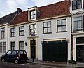
Category:Nieuwe Gracht 48, Haarlem
Jump to navigation
Jump to search
| Object location | | View all coordinates using: OpenStreetMap |
|---|
building in Haarlem, Netherlands  | |||||
| Upload media | |||||
| Instance of | |||||
|---|---|---|---|---|---|
| Location | Haarlem, North Holland, Netherlands | ||||
| Street address |
| ||||
| Located on street | |||||
| Heritage designation |
| ||||
 | |||||
|
This is a category about rijksmonument number 19589
|
| Address |
|
Media in category "Nieuwe Gracht 48, Haarlem"
The following 3 files are in this category, out of 3 total.
-
 En lager, overzicht - Haarlem - 20097034 - RCE.jpg 1,200 × 959; 306 KB
-
 Gevels - Haarlem - 20097030 - RCE.jpg 805 × 1,200; 193 KB
-
 Haarlem - Nieuwe Gracht 48 RM19589.JPG 3,834 × 3,084; 2.53 MB

