Category:Nieuw-Loosdrechtsedijk 175, Nieuw-Loosdrecht
Jump to navigation
Jump to search
| Object location | | View all coordinates using: OpenStreetMap |
|---|
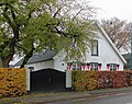
farmhouse in Wijdemeren, Netherlands  | |||||
| Upload media | |||||
| Instance of | |||||
|---|---|---|---|---|---|
| Location | Loosdrecht, Wijdemeren, North Holland, Netherlands | ||||
| Street address |
| ||||
| Heritage designation |
| ||||
 | |||||
|
This is a category about rijksmonument number 26187
|
| Address |
|
Media in category "Nieuw-Loosdrechtsedijk 175, Nieuw-Loosdrecht"
The following 2 files are in this category, out of 2 total.
-
 Aanzicht - Nieuw-Loosdrecht - 20165560 - RCE.jpg 1,191 × 1,200; 321 KB
-
 Nieuw Loosdrecht - Nieuw Loosdrechtsedijk 175 RM26187.JPG 3,635 × 2,890; 1.28 MB
